Kandahar Province
province of Afghanistan
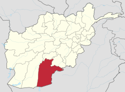
Kandahar or Qandahar (Pashto: کندھار or قندهار) (Persian: قندهار) is one of the largest of the thirty-four provinces of Afghanistan. It is located in southern Afghanistan, between Helmand, Oruzgan and Zabul provinces. Its capital is the city of Kandahar. There are about 913,000 people who live in the province.
Kandahar
| |
|---|---|
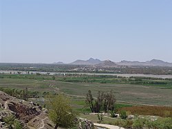
 View of Arghandab River Valley | |
| Nickname: Loy kandahar | |
 Map of Afghanistan with Kandahar highlighted | |
| Coordinates (Capital): 31°00′N 65°30′E / 31.0°N 65.5°E | |
| Country | |
| Capital | Kandahar |
| Government | |
| • Governor | Zalmay Wesa |
| Area | |
| • Total | 54,022 km2 (20,858 sq mi) |
| Population (2012) | |
| • Total | 1,151,100 |
| • Density | 21/km2 (55/sq mi) |
| Time zone | UTC+4:30 |
| Area code | AF-KAN |
| Main languages | Pashto |
Districts
changeThe following is a list of the districts of Kandahar Province:
| District | Capital | Population[1] | Area[2] | Notes |
|---|---|---|---|---|
| Arghandab | 51,600 | |||
| Arghistan | 28,900 | |||
| Daman | 24,800 | |||
| Ghorak | 8,000 | |||
| Kandahar | 468,200 | |||
| Khakrez | 19,200 | |||
| Maruf | 27,700 | |||
| Maywand | 40,700 | |||
| Miyanishin | 12,600 | Created in 2005 within Shah Wali Kot District | ||
| Nesh | 11,300 | Transferred from Oruzgan Province in 2005 | ||
| Panjwayi | 82,800 | |||
| Reg | 1,600 | |||
| Shah Wali Kot | 36,400 | Sub-divided in 2005 | ||
| Shorabak | 9,600 | |||
| Spin Boldak | 41,000 | |||
| Zhari | 49,500 | Created in 2005 from parts of Maywand and Panjwaye Districts |
References
change- ↑ Kandahar PDP Provincial profile Archived 2010-07-07 at the Wayback Machine, MRRD - National Area Base Development Programme
- ↑ Afghanistan Geographic & Thematic Layers