Meghalaya
Indian state
Meghalaya (Bengali: মেঘালায়া, ভারত) is a state within the Republic of India. Occupying an area of 8,660 mi² (22,429 km²),[2] bigger than the State of Israel but smaller than Belize.[3][4] Its capital is Shillong.[2] Meghalaya's population is 2,318,822.[2] The population of Shillong was 314,610 in 2001. There are problems in Meghalaya arise from the divide between tribals and non tribal settlers, identity issues and growing corruption besides the fear of being reduced to minority by native tribals. The activity status is classified as active. In traditional Indian geography it falls under the North-east Indian zone.
Meghalaya | |
|---|---|
State of India | |
 Location of Meghalaya in India | |
 Map of Meghalaya | |
| Country | |
| Region | Northeast India |
| Area | |
| • Total | 22,429 km2 (8,660 sq mi) |
| Population (2011) | |
| • Total | 2,966,889[1] |
| Time zone | UTC+05:30 (IST) |
Provincial symbols of Meghalaya
change-
 Provincial bird of Meghalaya
 -
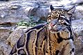 Provincial animal of Meghalaya
 -
 Provincial tree of Meghalaya
 -
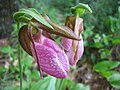 Provincial flower of Meghalaya


References
change- ↑ "Meghalaya Population 2011 - 2022". www.census2011.co.in. Retrieved 2022-03-06.
- ↑ 2.0 2.1 2.2 "At a Glance, Meghalaya". Meghalaya.nic.in. Archived from the original on 2011-10-31. Retrieved 2011-11-01.
- ↑ Federal Research Division (2004). Israel: A Country Study. Kessinger Publishing. p. 8. ISBN 978-1-4191-2689-5.
- ↑ "Belize - Location and size, Population, Industry, Mining, Manufacturing, Construction, Services". Nationsencyclopedia.com. 2011-02-07. Retrieved 2011-11-01.
Other websites
changeWikimedia Commons has media related to Meghalaya.
- Meghalaya Website Archived 2008-12-19 at the Wayback Machine