Montbéliard
Montbéliard is a French commune. It is in the north of the Doubs department in the Bourgogne-Franche-Comté region in eastern France, about 13 km (8 mi) from the border with Switzerland and is a subprefecture in the department. It is also the capital of the arrrondissement of Montbéliard.
Montbéliard | |
|---|---|
 Château de Montbéliard | |
 Coat of arms | |
Location of Montbéliard  | |
 Montbéliard  Montbéliard | |
| Coordinates: 47°30′37″N 6°47′56″E / 47.51027°N 6.79888°E | |
| Country | France |
| Region | Bourgogne-Franche-Comté |
| Department | Doubs |
| Arrondissement | Montbéliard |
| Canton | Montbéliard |
| Intercommunality | Pays de Montbéliard Agglomération |
| Government | |
| • Mayor (2014–2020) | Marie-Noëlle Biguinet[1] |
| Area 1 | 15.01 km2 (5.80 sq mi) |
| Population (2014) | 25,521 |
| • Density | 1,700/km2 (4,400/sq mi) |
| Time zone | UTC+01:00 (CET) |
| • Summer (DST) | UTC+02:00 (CEST) |
| INSEE/Postal code | 25388 /25200 |
| Elevation | 311–454 m (1,020–1,490 ft) (avg. 383 m or 1,257 ft) |
| Website | Ville de Montbéliard |
| 1 French Land Register data, which excludes lakes, ponds, glaciers > 1 km2 (0.386 sq mi or 247 acres) and river estuaries. | |
Montbéliard is the second commune of the department by its population, after Besançon, prefecture of the department.
Geography
changeThe city of Montbéliard is in the northeast of the Bourgogne-Franche-Comté region, in the northern part of the Doubs department.
The commune of Montbéliard has an area of 15.0 km2 (5.8 sq mi).[2] Its average altitude is 383 m (1,257 ft); at the city hall, the altitude is 330 m (1,080 ft).[3]
Two rivers flow through the commune:
- the Allaine river that is a right tributary of the Doubs river; and
- the Lizaine, a tributary of the Allaine.
The confluence of the two rivers is in the city of Montbéliard.
| Besançon | Paris | Bordeaux | Toulouse | Montpellier | Lyon | Nantes |
|---|---|---|---|---|---|---|
| 84 km (52 mi) | 482 km (300 mi) | 805 km (500 mi) | 806 km (501 mi) | 625 km (388 mi) | 328 km (204 mi) | 808 km (502 mi) |

|
The city of Montbéliard is surrounded by the communes:
Climate
changeThe Köppen climate classification type for Montbéliard is an "Oceanic climate" (also known as Maritime Temperate climate) and of the subtype Cfb.
Population
changeThe inhabitants of Montbéliard are known, in French, as Montbéliardais (women: Montbéliardaises).[4]
With a population of 25,521,[5] Montbéliard has a population density of 1,700 inhabitants/km2.
Evolution of the population in Montbéliard

Administration
changeMontbéliard is a subprefecture of the Doubs department, the capital of the arrondissement of Montbéliard and the administrative centre (French: chef-lieu) of the canton Montbéliard formed by 4 communes, including Montbéliard, with 30,173 inhabitants (2014).
It is part of the intercommunality Pays de Montbéliard Agglomération.
Twinned and partner towns
changeMontbéliard is twinned with:
Places of interest
changeSome interesting places in Montbéliard are:
- The Château de Montbéliard, the castle of the Dukes of Württemberg.
- Saint-Martin Protestant Temple.
- The Saint-Maimbœuf church.
Gallery
change-
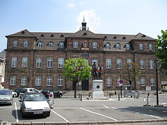 City hall of Montbéliard.
 -
 Château de Montbéliard.
 -
 The Saint-Martin Protestant Temple.
 -
 The Saint-Maimbœuf church and the Allaine river.
 -
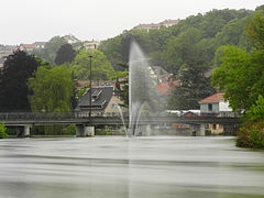 The Allaine river in Montbéliard.


Related pages
changeReferences
change- ↑ "Le Vos élus" (in French). Ville de Montbéliard. Retrieved 29 June 2017.
- ↑ "Commune de Montbéliard (25388) - Comparateur de territoire". Publications et statistiques pour la France ou les régions (in French). Institut national de la statistique et des études économiques - INSEE. Retrieved 29 June 2017.
- ↑ "The city of Montbéliard". Map-France.com. Retrieved 29 June 2017.
- ↑ "Doubs" (in French). habitants.fr. Retrieved 29 June 2017.
- ↑ "Régions, départements, arrondissements, cantons et communes" (PDF). Populations légales 2014 (in French). Institut national de la statistique et des études économiques - INSEE. Retrieved 29 June 2017.
Other websites
change- Ville de Montbéliard official website (in French)
- Pays de Montbéliard Agglomération website (in French)