Raigad district
district of Maharashtra , India
Raigad is a district located in the Konkan Division of Maharashtra, with its western boundary along the Arabian Sea coast. The headquarters of the district is Alibag.[1] The district boasts a landscape characterized by hilly areas, primarily within the Sahyadri mountain range. Formerly named Kolaba, it was later renamed Raigad District due to the popularity of one of it's fort named Raigad Fort.[2]
Raigad district | |
|---|---|
Clockwise from top-left: Elephanta Caves, Hills near Matheran, Kalamboli, Shivaji statue in Alibag, Hills around Raigad Fort, Taloja city | |
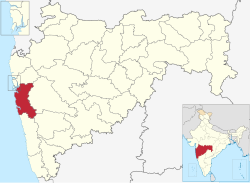
 Location in Maharashtra | |
| Country | |
| State | Maharashtra |
| Division | Konkan division |
| Headquarters | Alibag |
| Tehsils | 1. Alibag, 2. Panvel, 3. Murud, 4. Pen, 5. Uran, 6. Karjat, 7. Khalapur, 8. Mangaon, 9. Roha, 10. Sudhagad, 11.Tala, 12. Mahad, 13. Mhasala, 14. Shrivardhan, 15. Poladpur |
| Government | |
| • Body | Raigad Zilla Parishad Alibag |
| • Guardian Minister | Uday Samant (Cabinet Minister MH) |
| • President Z. P. Raigad | Ms. Yogita Pardhi |
| • District Collector | Dr. Yogesh Patilba Mhase (IAS) |
| • CEO Z. P. Raigad | Dr. Bharat Bastewad (IAS) |
| • MPs | Sunil Tatkare |
| Area | |
| • Total | 7,152 km2 (2,761 sq mi) |
| Population (2011) | |
| • Total | 2,634,200 |
| • Density | 370/km2 (950/sq mi) |
| • Urban | 36.91% |
| Demographics | |
| • Literacy | 83.14 |
| • Sex ratio | 959 per 1000 male |
| Time zone | UTC+05:30 (IST) |
| Major highways | NH-4, NH-66 |
| Average annual precipitation | 3,884 mm |
| Website | raigad |
Raigad is best known for its historical sites, beautiful beaches, attractive scenery, and the diverse plant and animal life found in the Western Ghats. The district also holds significant religious sites such as the Ashtavinayak Temples and Elephanta Caves, which bear witness to its culturally rich heritage.[3]
References
change- ↑ "Alibaug | Film Facilitation Office". ffo.gov.in. Retrieved 2023-09-28.
- ↑ "District Raigad, Government of Maharashtra | India". Retrieved 2023-09-28.
- ↑ "Raigad". DOT-Maharashtra Tourism. Retrieved 2023-09-28.


