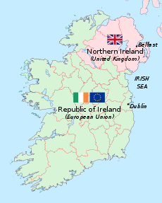
Republic of Ireland–United Kingdom border
international border
| Republic of Ireland–United Kingdom border | |
|---|---|
 A map showing the border | |
| Characteristics | |
| Entities | |
| Length | 499 km (310 mi) |
| History | |
| Established | 3 May 1921 Government of Ireland Act 1920 (Partition of Ireland) |
| Current shape | 7 December 1922 Northern Ireland opt out of the Free State |
| Treaties | Anglo-Irish Treaty Northern Ireland Protocol (as part of the Brexit Withdrawal Agreement) |
| Notes | Open border not officially marked by either government |
The Republic of Ireland – United Kingdom border is the border that separates the constituent British nation of Northern Ireland from the rest of Ireland. It is also known as the Irish Border or simply as the border. It was drawn on December 6, 1922 by the Anglo-Irish Treaty, by which 26 of the 32 Irish counties seceded from the United Kingdom and formed the Irish Free State.[1] However, the United Kingdom retained sovereignty over the remaining 6 counties, which are now an integral part of the United Kingdom.
References
change- ↑ Bremer, Juan José (2017). Penguin Random House Grupo (ed.). Tiempos de guerra y paz: Los pilares de la diplomacia: de Westfalia a San Francisco. ISBN 6073154135.