River Irwell
river in Lancashire, United Kingdom
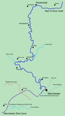
The River Irwell is a river which flows through the Irwell Valley in the counties of Lancashire and Greater Manchester in North West England. It is 39 miles (63 kilometres) long. The start of the river is at Irwell Springs on Deerplay Moor, about 1.5 miles (2.4 kilometres) north of the town of Bacup, in the parish of Cliviger, Lancashire. The Irwell flows through the city centres of Manchester and Salford, before joining the River Mersey near Irlam.
| River Irwell | |
|---|---|
 The River Irwell at Salford, looking towards Manchester city centre | |
 | |
| Location | |
| Country | United Kingdom |
| Constituent country | England |
| Region | North West England |
| Physical characteristics | |
| Source | Irwell Springs |
| - location | Deerplay Moor, Cliviger, Lancashire |
| - coordinates | 53°44′10″N 2°11′59″W / 53.73611°N 2.19972°W |
| - elevation | 400 m (1,300 ft) |
| Mouth | River Mersey |
| - location | Manchester Ship Canal, Salford |
| Discharge | |
| - location | Adelphi Weir |
| - average | 17.72 m3/s (626 cu ft/s) |
| Basin features | |
| Tributaries | |
| - left | Croal |
| - right | Roch, Irk, Medlock |
Other websites
changeMedia related to River Irwell at Wikimedia Commons
- History of the Mersey and Irwell Navigation (Old Quay Company) Archived 2007-11-07 at the Wayback Machine
- Salford Quays virtual tour
- The Transport Archive: Canal archive: Mersey and Irwell Navigation[permanent dead link]
- Pennine Waterways: Images of the River Irwell Navigation
| KML file (edit • help)
|