Salto Department
The Salto department (Spanish: Departamento de Salto) is a department of Uruguay. The capital is the city of Salto.
Salto | |
|---|---|
 A street in the city of Salto. | |
 Flag  Coat of arms | |
 Location of Salto, in red, in Uruguay | |
| Coordinates: 31°18′57″S 57°2′12″W / 31.31583°S 57.03667°W | |
| Country | |
| Creation | 17 June 1837 |
| Capital | Salto |
| Government | |
| • Intendant | Andrés Lima[1] |
| Area | |
| • Total | 14,163 km2 (5,468 sq mi) |
| Population (2011)[2] | |
| • Total | 124,878 |
| • Density | 8.8/km2 (23/sq mi) |
| Time zone | UTC-03 (UYT) |
| ISO 3166 code | UY-SA |
| Website | Official website |
Its ISO 3166-2 code is UY-SA.
Name
changeThe name of the department and of its capital city comes from the presence of small waterfalls (Spanish: Saltos) in the Uruguay river.
History
changeThe Salto department was made on 17 June 1837; then, the department included the present Artigas Department. Its final borders were defined on 1 October 1884, when the Artigas department was separated from Salto.
Geography
change
The Salto department is in the northwestern part of the country. It has an area of 14,163 km2 (5,468 sq mi), the second largest in the country after the Tacuarembó department. It is the fourth department with more people living in it, with a population of 124,878 inhabitants (2011 census) for a population density of 10.5.
There are two chains of low and rounded hills in the department. These chains of are known as cuchillas in the country. The two cuchillas in the department are the cuchilla de los Arapeyes to the north, and the cuchilla del Daymán that runs across the department from the southeast to the northeast. Between these two chains is the valley of the Arapey Grande river.
Limits
change- To the north: Artigas department.
- To the east: Rivera and Tacuarembó departments
- To the south: Paysandú department.
- To the west: Argentina, separated by the Uruguay river.
Rivers
changeThe main rivers in the department are:
- Uruguay river to the west; it makes the border with Argentina.
- Arapey Grande river, a tributary of the Uruguay river.
- Daymán river to the south; it is also a tributary of the Uruguay river and forms the border with the Paysandú department.
Climate
changeThe Köppen climate classification type for the climate in the city of Salto is a "Humid subtropical climate" and of the subtype Cfa.[3]
The average amount of precipitation for the year in Salto is 1,277.6 mm (50.3 in). The month with the most precipitation on average is March with 137.2 mm (5.4 in) of precipitation. The month with the least precipitation on average is August with an average of 66 mm (2.6 in).
The average temperature for the year in Salto is 18.1 °C (64.6 °F). The warmest month, on average, is January with an average temperature of 25 °C (77 °F). The coolest month on average is June, with an average temperature of 11.7 °C (53.1 °F).
Demographics
changeThe inhabitants of the Salto department (and of the city of Artigas) are known, in Spanish, as Salteños (women: Salteñas.
Evolution of the population in Salto

- Rural population
According to the 2011 census, the Artigas department has a rural population of 7,849.[2]
- Main towns
| City / Town | Population (2011) |
|---|---|
| Salto | 104,028 |
| Constitución | 2,762 |
| Belén | 1,926 |
| Pueblo Lavalleja | 956 |
| San Antonio | 877 |
Gallery
change-
-
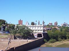
 "Horacio Quiroga" Park, in Termas de Salto Grande, Salto.
 -

-
 Treinta y Tres square, Salto.
 -
 Museum of Man and Technology, Salto.


Related pages
changeReferences
change- ↑ "Intendente Municipal" (in Spanish). Intendencia de Salto. Retrieved 22 July 2017.
- ↑ 2.0 2.1 "Censos 2011". Instituto Nacional de Estadística. 10 August 2012. Archived from the original on 5 March 2011. Retrieved 22 July 2017.
- ↑ "Salto, Uruguay - Köppen Climate Classification". Weatherbase. Retrieved 22 July 2017.
Other websites
change- Intendencia de Salto website (in Spanish)
- Enciclopedia Geográfica del Uruguay|Salto (in Spanish)
- Statoids - Departments of Uruguay