Shakargarh
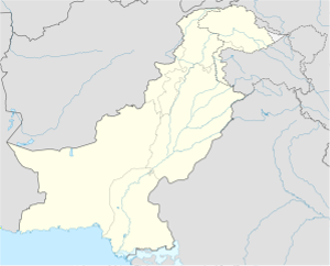
Shakargarh is a city in the north-east of Pakistan in Narowal District of Punjab province. It is the headquarters of Shakargarh Tehsil.[1] The city is at 32°16'0N 75°10'0E and is on the west bank of the Ravi River.[2]
Shakargarh | |
|---|---|
| Coordinates: 32°1′N 75°10′E / 32.017°N 75.167°E | |
| Country | |
| Province | Punjab |
| District | Narowal District |
| Established | 1991 |
| Incorporated | 1991 |
| Area | |
| • Total | 1,272 km2 (491 sq mi) |
| Population (2006) | |
| • Total | 1,256,097 |
| Time zone | UTC+5 (PST) |
| Postal code span | |
| Area code | 0542 |
History
changeIn old times Shakargarh was used as a route for the Mughals to enter Gurdaspur and going to Delhi. During British rule (before the independence of Pakistan), Shakargarh became the capital of Shakargarh Tehsil.
In 1947 when the British were leaving, they divided British India between Pakistan and the modern republic of India. The border between the two countries was known as the Radcliffe Line (this was named after Cyril John Radcliffe who drew the borders). The line divided Shakargarh from the rest of Gurdaspur district (which then became part of India). Shakargarh then became part of Sialkot District, however when Narowal District was created in 1991, Shakargarh became part of that district.
References
change- ↑ "Tehsils & Unions in the District of Narowal - Government of Pakistan". Archived from the original on 2008-04-01. Retrieved 2008-12-10.
- ↑ Location of Shakargarr - Falling Rain Genomics
