South Mills, North Carolina
census-designated place in Camden County, North Carolina
South Mills is an unincorporated community and census-designated place (CDP) in Camden County, North Carolina, United States.[2] Its population was 362 as of the 2020 census.[3] South Mills has a post office with ZIP code 27976, which opened on March 2, 1840.[4][5] The community is located near U.S. Route 17. U.S. Route 17 Business and North Carolina Highway 343 pass through the community.
South Mills, North Carolina | |
|---|---|
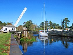
 Highway bridge open for passage of sailboat at South Mills on the Intracoastal Waterway (Dismal Swamp Canal) | |
 Location in Camden County and the state of North Carolina. | |
| Coordinates: 36°26′16″N 76°19′51″W / 36.43778°N 76.33083°W | |
| Country | United States |
| State | North Carolina |
| County | Camden |
| Area | |
| • Total | 1.79 sq mi (4.64 km2) |
| • Land | 1.79 sq mi (4.64 km2) |
| • Water | 0.00 sq mi (0.00 km2) |
| Elevation | 3 ft (0.9 m) |
| Population | |
| • Total | 362 |
| • Density | 202.12/sq mi (78.05/km2) |
| Time zone | UTC-5 (Eastern (EST)) |
| • Summer (DST) | UTC-4 (EDT) |
| ZIP code | 27976 |
| Area code | 252 |
| GNIS feature ID | 2628656[2] |
| FIPS code | 37-63340 |
The William Riley Abbott House, Dismal Swamp Canal, and Morgan House are listed on the National Register of Historic Places.[6]
References
change- ↑ "ArcGIS REST Services Directory". United States Census Bureau. Retrieved September 20, 2022.
- ↑ 2.0 2.1 2.2 U.S. Geological Survey Geographic Names Information System: South Mills, North Carolina
- ↑ 3.0 3.1 "Profile of General Population and Housing Characteristics: 2020 Demographic Profile Data (DP-1): South Mills CDP, North Carolina". United States Census Bureau. Retrieved February 26, 2024.
- ↑ United States Postal Service (2012). "USPS - Look Up a ZIP Code". Retrieved February 15, 2012.
- ↑ "Postmaster Finder - Post Offices by ZIP Code". United States Postal Service. Archived from the original on April 28, 2019. Retrieved March 6, 2014.
- ↑ "National Register Information System". National Register of Historic Places. National Park Service. July 9, 2010.