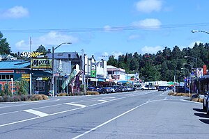
Taihape
town in New Zealand
Taihape is a town in the Rangitikei District, New Zealand. It is located on State Highway 1 and is 102 kilometers northwest of Palmerston North and 29 southeast of Waiouru. There are two schools situated in the town.
Taihape | |
|---|---|
 | |
 | |
| Coordinates: 39°40.6′S 175°47.8′E / 39.6767°S 175.7967°E | |
| Country | New Zealand |
| Region | Manawatū-Whanganui |
| District | Rangitikei District |
| Wards |
|
| Community | Taihape Community |
| Early settlement | pre-European |
| Taihape | 1894 |
| Named for | Shortened form of Ōtaihape. |
| Electorates | |
| Government | |
| • Territorial Authority | Rangitikei District Council |
| • Regional council | Horizons Regional Council |
| Area | |
| • Total | 4.93 km2 (1.90 sq mi) |
| Population (June 2023)[2] | |
| • Total | 1,800 |
| • Density | 370/km2 (950/sq mi) |
| Postcode | 4720 |
| Area code | 06 |

References
change- ↑ Cite error: The named reference
Areawas used but no text was provided for refs named (see the help page). - ↑ "Subnational population estimates (RC, SA2), by age and sex, at 30 June 1996-2023 (2023 boundaries)". Statistics New Zealand. Retrieved 25 October 2023. (regional councils); "Subnational population estimates (TA, SA2), by age and sex, at 30 June 1996-2023 (2023 boundaries)". Statistics New Zealand. Retrieved 25 October 2023. (territorial authorities); "Subnational population estimates (urban rural), by age and sex, at 30 June 1996-2023 (2023 boundaries)". Statistics New Zealand. Retrieved 25 October 2023. (urban areas)