Thouet
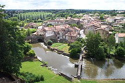
The Thouet is a river in western France, flowing through the Deux-Sèvres and Maine-et-Loire departments, in the Nouvelle-Aquitaine and Pays de la Loire regions.
| Thouet | |
|---|---|
 | |
| Location | |
| Country | France |
| Physical characteristics | |
| Mouth | |
| - location | Loire |
| - coordinates | 47°16′47″N 0°6′38″W / 47.27972°N 0.11056°W |
| Length | 142 km (88 mi) |
| Basin size | 3,396 km2 (1,311 sq mi) |
| Basin features | |
| Progression | Loire→ Atlantic Ocean |
Geography
changeThe Thouet river has a length of 142.5 km (89 mi) and a drainage basin with an area of approximately 3,282 km2 (1,267 sq mi).[1]
Course
changeThe Thouet starts in the Gâtine plateau, west of the Deux-Sèvres department, in the commune of Le Beugnon, near Secondigny and close to the source of the Sèvre Nantaise river, at an elevation of about 223 m (732 ft).[2] From the source to Parthenay the river flows in a generally southwest-northwest direction. To the east of Parthenay, the river turns north and flows on a generally northward direction for the rest of its course.
Finally, the river flows into the Loire river in the city of Saumur.[3]
The Thouet flows through 2 regions, 2 departments and 34 communes; some of them are:[1]
- Nouvelle-Aquitaine region
- Pays de la Loire region
Main tributaries
changeThe main tributaries of the Thouet river are:[1]
|
Left tributaries:
|
|
Right tributaries:
|
Gallery
change-
The Thouet in Montreuil-Bellay
-
The Château of Thouars from the Thouet river
-
The Thouet in Thouars
Related pages
changeReferences
change- ↑ 1.0 1.1 1.2 "Le Thouet (L8--0210)" (in French). SANDRE - Portail national d'accès aux référentiels sur l'eau. Archived from the original on 20 May 2015. Retrieved 25 August 2016.
- ↑ "Source du Thouet" (in French). Géoportail. Retrieved 25 August 2016.
- ↑ "Confluence du Thoue" (in French). Géoportail. Retrieved 25 August 2016.[permanent dead link]
Other websites
change- Banque Hydro - Station L8102120 - La Sèvre Niortaise à Tallud Archived 2020-02-03 at the Wayback Machine (in French)
- Histoire & Patrimoine des Rivières & Canaux (in French)

