Var (river)
The Var (Latin: Varus) is a river in southeastern France. It is a right tributary of the Rhône river.It gave its name to the French department of Var. It is a unique case in France of a river not flowing in the department named after it (see Var)
| Var | |
|---|---|
 Rooftops of Entrevaux and the gorge of the Var | |
 | |
| Location | |
| Country | France |
| Physical characteristics | |
| Source | |
| - location | Maritime Alps |
| - elevation | 1,800 m (5,900 ft) |
| Mouth | |
| - location | Mediterranean Sea |
| - coordinates | 43°39′13″N 7°11′59″E / 43.65361°N 7.19972°E |
| Length | 114 km (71 mi) |
| Basin size | 2,812 km2 (1,086 sq mi) |
| Discharge | |
| - average | 50 to 100 m3/s (1,800 to 3,500 cu ft/s) |
Geography
changeThe Var river has a length of 113.8 km (70.7 mi), and a drainage basin with an area of 2,819 km2 (1,088 sq mi).[1]
Its average yearly discharge (volume of water which passes through a section of the river per unit of time) is 50.40 m3/s (1,780 cu ft/s) at Nice (Pont Napoléon III) in the Alpes-Maritimes department.[2]
Course
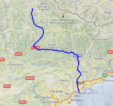
changeThe source of the Var is in the small town of Estenc, in the commune of Entraunes, at an altitude of about 1,790 m (5,873 ft), to the south of the Col de la Cayolle, a mountain pass 2,326 m (7,631 ft) high, in the Alpes-Maritimes department.[3] From here, the Var flows, in general, to the southeast.
The Var flows through the Alpes-Maritimes department for most of its length; it flows through the Alpes-de-Haute-Provence department for a short distance, about 15 km (9.3 mi).
The Var river flows through 1 region (Provence-Alpes-Côte d'Azur), 2 departments and 31 communes. It flows through the following communes, among others:[1]
- Alpes-Maritimes: Guillaumes
- Alpes-de-Haute-Provence: Entrevaux
- Alpes-Maritimes: Puget-Théniers, Carros, Saint-Laurent-du-Var
Finally, it flows into the Mediterranean Sea between Nice and Saint-Laurent-du-Var.[4]
Main tributaries
changeThe five main tributaries of the Var river are:[1]
|
Left tributaries:
|
|
Right tributaries:
|
Related pages
changeReferences
change- ↑ 1.0 1.1 1.2 "Le Var (Y6--0200)" (in French). SANDRE - Portail national d'accès aux référentiels sur l'eau. Archived from the original on 16 February 2015. Retrieved 19 November 2016.
- ↑ "Le Var à Nice [Pont Napoléon III]". Banque Hydro (in French). Ministère de l'Ecologie, du Développement Durable et de l'Energie. Archived from the original on 3 March 2016. Retrieved 19 November 2016.
- ↑ "Source du Var" (in French). Géoportail. Retrieved 20 November 2016.
- ↑ "Embouchure du Var" (in French). Géoportail. Retrieved 20 November 2016.