Vipava (river)
The Vipava (in Slovene), Vipacco (in Italian) or Vipau (in Friulian)[3] is a river that flows through western Slovenia and northeastern Italy.
| Vipava | |
|---|---|
 The Vipava in Vipava, flowing under the Tabor Bridge | |
| Location | |
| Country | Italy, Slovenia |
| Physical characteristics | |
| Source | |
| - location | Vipava (in Slovenia) |
| - elevation | 110 m (360 ft) [1] |
| Mouth | |
| - location | The Soča (in Italy) |
| - coordinates | 45°53′56″N 13°33′12″E / 45.8990°N 13.5533°E |
| - elevation | 35 m (115 ft) [1] |
| Length | 49 km (30 mi) [1] |
| Basin size | 760 km2 (290 sq mi) |
| Discharge | |
| - average | 17.31 m3 (611 cu ft)[2] |
| Basin features | |
| Progression | Soča→ Adriatic Sea |
The Battle of the Frigidus was fought in 394 near the river, which was named Frigidus ('cold') by the Romans.
Geography
change
The Vipava river has a length of 49 km (30 mi), 44 km (27 mi) in Slovenia and 5 km (3 mi) in Italy.[4] Its drainage basin has an area of about 760 km2 (293 sq mi) (598 km2 (231 sq mi) in Slovenia).[4]
The river flows through the southern part of the Vipava valley; this valley goes from the village of Podnamos, Slovenia, to Savogna d'Isonzo, in Italy.
Course
changeThe source of the Vipava is close to the city of Vipava,[5] in the municipality of Vipava, western Slovenia, at an altitude of 110 m (361 ft).[4]
From its source, the Vipava flows to the northwest and follows this direction through the Vipava valley. It passes through the Slovenian municipalities of Vipava, Ajdovščina, Nova Gorica, Renče–Vogrsko and Miren–Kostanjevica. Then, at an altitude of 35 m (115 ft),[4] the river crosses the border and gets into the Italian comune of Savogna d'Isonzo (Friuli-Venezia Giulia region) and finally joins the Soča river.[5]
There are not important tributaries, only very small streams.
Gallery
change-
 Tabor bridge across the river Vipava in Vipava.
 -
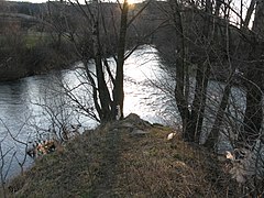 Confluence of rivers Vipava and Hubelj.
 -
 Vipava valley from Nanos.
.jpg)

Related pages
changeReferences
change- ↑ 1.0 1.1 1.2 Rivers, longer than 25 km, and their catchment areas, Statistical Office of the Republic of Slovenia
- ↑ "Vipava" [Camis Project: Coherent Activities for the Management of the River Soča]. Projekt Camis - Usklajene aktivnosti za upravljanje reke Soče (in Slovenian and Italian). Soča Development Centre. Retrieved 8 February 2006.[permanent dead link]
- ↑ "Denominazioni toponimiche ufficiali in lingua friulana" (PDF) (in Italian). ARLeF. 9 February 2014. Archived from the original (pdf) on 8 October 2014. Retrieved 2 September 2014.
- ↑ 4.0 4.1 4.2 4.3 "Reke, dolge nad 25 km, in njihova padavinska obmocja" [Rivers, longer than 25 km, and their catchment areas] (in Slovenian and English). Statistical Office of the Republic of Slovenia. 2002. Archived from the original on 20 October 2007. Retrieved 9 September 2014.
- ↑ 5.0 5.1 "Kart over Vipava" (in Slovenian). Geopedia.si. Archived from the original on 29 July 2017. Retrieved 9 September 2014.
Other websites
change- A map of the Vipava Archived 2017-07-29 at the Wayback Machine. Geopedia.si online project. Retrieved 30 March 2008.