Viqueque Municipality
Viqueque (Tetum: Vikeke) is the largest of the municipalities of East Timor. The name comes from the ancient name "We Keke"; We means "water" and Keke "bracelet".[2]
Viqueque | |
|---|---|
| |
 Rice fields in Viqueque | |
 Seal  Official map | |

| |
OpenStreetMap  | |
| Coordinates: 8°47′S 126°22′E / 8.783°S 126.367°E | |
| Country | |
| Capital | Viqueque |
| Administrative posts | |
| Area | |
| • Total | 1,872.7 km2 (723.1 sq mi) |
| • Rank | 1st |
| Population (2015 census) | |
| • Total | 73,033 |
| • Rank | 5th |
| • Density | 39/km2 (100/sq mi) |
| • Rank | 10th |
| Households (2015 census) | |
| • Total | 15,297 |
| • Rank | 5th |
| Time zone | UTC+09:00 (TLT) |
| ISO 3166 code | TL-VI |
| HDI (2017) | 0.602[1] medium · 9th |
| Website | Viqueque Municipality |
Geography
change

Viqueque is on the south coast of Timor, on the Timor Sea. It has an area of 1,880.39 km2 (726.02 sq mi).[3]
It borders the municipalities Baucau to the north, Lautém to the east, and Manatuto to the west.
The capital of the municipality has the same name: Viqueque.
There are five administrative posts: Lacluta, Ossu, Uato-Lari (which was known in Portuguese Timor as Leça, and, in Tetum, is spelled Watulari), Uato Carabau (spelled Watucarbau in Tetum), and Viqueque.
Among the rivers that flow through Viqueque and into the Timor Sea are: Nunuc, Tuco, Cuha, Bularan, Benaro, Beaco and Weburak in the administrative post Viqueque; Lugassa on the border with Uato -Lari; Saqueto, Bebui, Borouai and Oiqui in the Uato-Lari administrative post; and Molaiuai and Uaidori in the Uatucarbau administrative post.
The Ossu administrative post is surrounded by several mountains: Monte Mundo Perdido in the west, the Builo in the south, the Matebian massif to the east and Fatu Laritame in the north. In Monte Mundo Perdido, 16,100 hectares (40,000 acres) are protected for hunting and for the protection of birds as Important Bird Area. Here, there are many endemic species, including many rare orchids.[4]
Population
changeThe municipality of Viqueque had a population of 73,581 in 2011.[5] Its density is 39.1 inhabitants per km².
Viqueque is a homeland of the Malayo-Polynesian language Tetum. In East Timor it is co-official with Portuguese. In the east part of the municipality live speakers of the Papuan language Makasae.
Gallery
change-
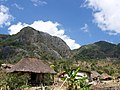 Small town near Monte Mundo Perdido
 -
 Water buffalos on the road to Viqueque
 -
 Tebe Dahur dance
 -


.jpg)

References
change- ↑ "Sub-national HDI - Area Database - Global Data Lab". hdi.globaldatalab.org. Retrieved 2018-09-13.
- ↑ "Koba Lima – Suai". Suai Media Space. Retrieved 15 September 2013.
- ↑ "2010 Census Wall Chart (English)" (PDF). Direcção Nacional de Estatística. Archived from the original (pdf) on 12 August 2011. Retrieved 15 September 2013.
- ↑ "A lost world in Timor- Leste. Mount Mundo Perdido. A profile of its biodiversity and conservation" (PDF). Bird Life International. Archived from the original (pdf) on 30 November 2010. Retrieved 15 September 2013.
- ↑ "Timor-Leste in figures 2011" (PDF). Direcção Nacional de Estatística. Archived from the original (pdf) on 19 February 2014. Retrieved 15 September 2013.