A4 autoroute
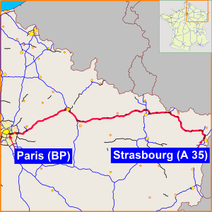
controlled-access highway from Paris to Strasbourg
The A4, also called the Autoroute de l'Est (Autoroute of the East) in French, is an autoroute (motorway) in France. It is the third-longest autoroute in France. It is 488 kilometres (303 mi) long.[1] The A10 is the longest (549 kilometres (341 mi)), the A89 is the second-longest (544 kilometres (338 mi)). The A4 connects Paris with Strasbourg. It is part of the E25 and E50 European routes. The A4 goes past Disneyland Paris, linking it with the city of Paris. The autoroute also goes through the cities of Reims and Metz. The end of the autoroute in Strasbourg joins onto the A35 autoroute towards Mulhouse and Switzerland. [2]
| A4 autoroute | |
|---|---|
| Autoroute de l'Est | |
 | |
| Route information | |
| Part of | |
| Length | 488 km (303 mi) |
| Existed | 1974–present |
| Major junctions | |
| West end | Paris (Porte de Bercy) |
| East end | Strasbourg |
| Location | |
| Country | France |
| Highway system | |
| |
Exits and junctions
change| Exit/Junction | Destination | |
| Boulevard Périphérique | ||
| 2 (westbound only) | Charenton | |
| 3 | Maisons Alfort, St Maurice | |
| 4 | A 86, Joinville-le-Pont Bordeaux, Nantes, Lyon | |
| 5 | A 86, Nogent-sur-Marne A1, Lille, Bobigny | |
| 6 (Eastbound only) | Champingy-sur-Marne | |
| 8 | Marne-la-Vallée Porte de Paris | |
| 9 (Westbound only) | Noisy le Grand - Centre | |
| 10 | Marne-la-Vallée Cite D'escartes | |
| N 104 | ||
| 10.1 | Marne-la-Vallée Val Maubué, | |
| A 104 Lille, Charles de Gaulle | ||
| 12 | Marne-la-Vallée Val de Bussy | |
| 12.1 (Eastbound only) | Marne-la-Vallée Val d'Europe | |
| 13 | Marne-la-Vallée Val de Lagny Provins | |
| 14 | Marne-la-Vallée Val d'Europe
Parcs DISNEY | |
| 15 (Westbound only) | Coutevroult | |
| 16 | Crécy-la-Chapelle | |
| A 140 Meaux | ||
| 18 | St. Jean-les-Deus-Jumeaux | |
| 19 | Montreuil-aux-Lions | |
| 20 | Château-Thierry | |
| 21 | Dormans | |
| 22 | A 344
Reims Centre -Tinqueux | |
| A 26 (North) Calais, Brussels, Lille | ||
| 23 | Epernay, Reims Sud | |
| A 34 Charleroi, Reims Est | ||
| A 26 (South) Troyes Lyon | ||
| 27 | La Veuve | |
| 28 | St. Etienne-au-Temple | |
| 29 | Sainte-Menehould | |
| 29.1 | Clermont-en-Argonne | |
| 30 | Voie Sacrée | |
| 31 | Verdun | |
| 32 | Fresnes-en-Woëvre | |
| 33 | Jarny | |
| 34a (Eastbound only) | Batilly | |
| 34/34b | Ste. Marie | |
| 35 | Marange-Silvange | |
| 36 | Sémécourt | |
| A 31, Croix de Hauconcourt | ||
| 37 | Argancy | |
| A 315, Bifurcation de Mey | ||
| A 314, Bifurcation de Lauvallières | ||
| 38 | Boulay | |
| 39 | Saint-Avold | |
| 40 | A 320, Freyming-Merlebach | |
| 41 | Farébersviller | |
| 41.1 (Eastbound only) | Puttelange | |
| 42 | Sarreguemines | |
| 43 | Sarre-Union | |
| 44 | Phalsbourg ( N 4) | |
| 45 | Saverne | |
| 46 | Hochfelden | |
| 47 | A 340, Brumath-nord | |
| 48 | Brumath-sud | |
| A 35 | ||
| 49 | Reichstett | |
| 49.1 | Hoenheim | |
| 50 | Bischheim | |
| 51 | Strasbourg-centre | |
References
change- ↑ "LA ROUTE. Sur l'A4, le péage de Saint-Avold rapporte 200 000 € par jour". www.republicain-lorrain.fr (in French). Retrieved 2020-06-23.
- ↑ "A4 motorway - Live traffic, travel time, roadworks and closures". SANEF/SAPN. Archived from the original on 28 May 2020. Retrieved 22 June 2020.
