Arrast-Larrebieu
commune in Pyrénées-Atlantiques, France
Arrast-Larrebieu is a commune of the Pyrénées-Atlantiques département in the southwestern part of France. It is in the former province of Soule. It is mostly agricultural.
Arrast-Larrebieu | |
|---|---|
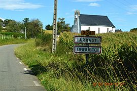
 The road into Arrast | |
| Coordinates: 43°17′39″N 0°50′56″W / 43.2942°N 0.8489°W | |
| Country | France |
| Region | Nouvelle-Aquitaine |
| Department | Pyrénées-Atlantiques |
| Arrondissement | Oloron-Sainte-Marie |
| Canton | Montagne Basque |
| Intercommunality | CA Pays Basque |
| Government | |
| • Mayor (2014–2020) | Allande Davant |
| Area 1 | 7.56 km2 (2.92 sq mi) |
| Population (2009) | 102 |
| • Density | 13/km2 (35/sq mi) |
| Time zone | UTC+01:00 (CET) |
| • Summer (DST) | UTC+02:00 (CEST) |
| INSEE/Postal code | 64050 /64130 |
| Elevation | 132–299 m (433–981 ft) (avg. 173 m or 568 ft) |
| 1 French Land Register data, which excludes lakes, ponds, glaciers > 1 km2 (0.386 sq mi or 247 acres) and river estuaries. | |
Population
change
| |||||||||||||||||||||||||||
| |||||||||||||||||||||||||||
| |||||||||||||||||||||||||||
| |||||||||||||||||||||||||||


