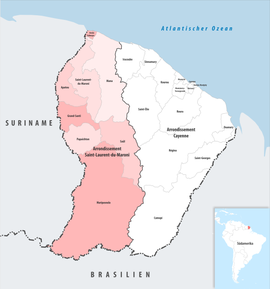
Arrondissement of Saint-Laurent-du-Maroni
arrondissement of Algeria
The arrondissement of Saint-Laurent-du-Maroni is an arrondissement of France, in the French Guiana department. Its capital, and subprefecture of the department, is the city of Saint-Laurent-du-Maroni.
Saint-Laurent-du-Maroni | |
|---|---|
 Location within French Guiana | |
| Country | France |
| Overseas region and department | French Guiana |
| No. of communes | 8 |
| Subprefecture | Saint-Laurent-du-Maroni |
| Area | 40,945 km2 (15,809 sq mi) |
| Population (2016) | 92,995 |
| INSEE code | 9732 |
History
changeThe arrondissement of Saint-Laurent-du-Maroni was created in 1969.
Geography
changeThe arrondissement of Saint-Laurent-du-Maroni is in the western half of the department. It has the Atlantic Ocean to the north, the Cayenne arrondissement to the east, Brazil to the south, and Surinam to the west.
The arrondissement of Cayenne has an area of 40,945 km2 (15,809 sq mi) and a population of 87,849 inhabitants.
Composition
changeThe arrondissement of Saint-Laurent-du-Maroni has 8 communes; they areː[1]
| INSEE code |
Commune | Population[2] (2014) |
Area | Density (inh./km²) |
Intercommunality |
|---|---|---|---|---|---|
| Arrondissement of Saint-Laurent-du-Maroni | |||||
| 97311 | Saint-Laurent-du-Maroni | 44,169 | 4,830.00 | 9.14 | L'Ouest Guyanais |
| 97353 | Maripasoula | 10,984 | 18,360.00 | 0.60 | L'Ouest Guyanais |
| 97306 | Mana | 9,916 | 6,332.60 | 1.57 | L'Ouest Guyanais |
| 97360 | Apatou | 8,040 | 2,020.00 | 3.98 | L'Ouest Guyanais |
| 97357 | Grand-Santi | 6,656 | 2,123.00 | 3.14 | L'Ouest Guyanais |
| 97362 | Papaichton | 6,572 | 2628.00 | 2.50 | L'Ouest Guyanais |
| 97361 | Awala-Yalimapo | 1,364 | 187.40 | 7.28 | L'Ouest Guyanais |
| 97322 | Saül | 148 | 4,475.00 | 0.03 | L'Ouest Guyanais |
Related pages
changeReferences
change- ↑ "Département de la Guyane (973)". Géographie administrative et d'étude (in French). Institut national de la statistique et des études économiques - INSEE. Retrieved 12 February 2017.
- ↑ "Régions, départements, arrondissements, cantons et communes" (PDF). Populations légales 2014 (in French). Institut national de la statistique et des études économiques - INSEE. Retrieved 12 February 2017.