Benton County, Indiana
county in Indiana, United States
Benton County is a county in Indiana. Its county seat is Fowler. About 93% of the land in the county is used for growing crops, mainly corn and soybeans.[2]
Benton County | |
|---|---|
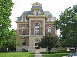
 Benton County Courthouse in Fowler, Indiana. | |
 Location within the U.S. state of Indiana | |
 Indiana's location within the U.S. | |
| Coordinates: 40°37′N 87°19′W / 40.61°N 87.31°W | |
| Country | |
| State | |
| Founded | 18 February 1840 |
| Named for | Senator Thomas H. Benton |
| Seat | Fowler |
| Largest city | Fowler |
| Area | |
| • Total | 406.51 sq mi (1,052.9 km2) |
| • Land | 406.42 sq mi (1,052.6 km2) |
| • Water | 0.09 sq mi (0.2 km2) 0.02% |
| Population | |
| • Total | 8,719 |
| • Density | 21/sq mi (8.3/km2) |
| Time zone | UTC−5 (Eastern) |
| • Summer (DST) | UTC−4 (EDT) |
| Congressional district | 4th |
| Website | www |
| |
Cities
changeThere are no cities in this county. The largest town, Fowler, in 2020 had a population of 2,337.[3]
Towns
changeWind farms
changeThere are three large wind farms in the county:[4]
- Benton County Wind Farm - 135 turbines
- Fowler Ridge Wind Farm - 460 turbines
- Hoosier Wind Farm - 53 turbines
References
change- ↑ "QuickFacts: Benton County, Indiana". United States Census Bureau. Retrieved September 25, 2023.
- ↑ "Benton County, Indiana - agriculture". bentoncounty.in.gov. 2014. Archived from the original on 30 November 2013. Retrieved 5 January 2014.
- ↑ "Fowler town, Indiana". United States Census Bureau. Retrieved September 25, 2023.
- ↑ "Benton County, Indiana - wind farms". bentoncounty.in.gov. 2014. Archived from the original on 14 January 2017. Retrieved 5 January 2014.
