Biberkopf
mountain in the Allgäu Alps at the border of Tyrol, Austria and Bavaria, Germany
The Biberkopf is a mountain in the Alps. It is on the border between Germany and Austria.[1] The mountain is 2,599 metres (8,527 ft) high.
| Biberkopf | |
|---|---|
 The Biberkopf seen from the northwest, near the Mindelheim Hut | |
| Highest point | |
| Elevation | 2599m |
| Prominence | 337 m ↓ Große Steinscharte → Steinschartenkopf |
| Isolation | 3.5 km → Hohes Licht |
| Coordinates | 47°16′14″N 10°13′56″E / 47.270528°N 10.232361°E |
| Geography | |
| Parent range | Central ridge, Allgäu Alps |
| Climbing | |
| First ascent | 1853 during topographical survey |
| Easiest route | Rappensee Hut - marked route (roped in places) - western arête - summit |

The Biberkopf is on the main ridge of the Allgäu Alps. It forms a border between Bavaria, Germany and Tyrol, Austria. It is about 15.5 km southwest of Oberstdorf and about 2.5 km east of the Schrofen Pass. The Biberkopf is sometimes called the most southerly point in Bavaria and Germany. However, its summit is 110 metres further north than the Haldenwanger Eck, which is 4,088 metres to the west. The mountain is made of dolomite.
Gallery
change-
 The Biberkopf from the south
 -
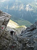 On the way up


Other reading / maps
change- Dieter Seibert, Alpenvereinsführer Allgäuer Alpen und Ammergauer Alpen, Munich 2004, ISBN 3-7633-1126-2
- Alpenvereinskarte 1:25,000, Sheet3/2, Lechtaler Alpen, Arlberggebiet (The Biberkopf is right on the northern edge of the map, the Rappensee Hut is off the map)
- Bayerisches Landervermessungsamt, 1:50.000, Sonderdruck Allgäuer Alpen, Blatt UK L8