Colorado River
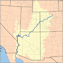
The Colorado River is a river in the southwestern United States and northwestern Mexico. It is approximately 1,450 miles (2,330 km) long. It drains a part of the dry regions on the western slope of the Rocky Mountains.
| Colorado River | |
|---|---|
 Map of the Colorado Watershed | |
| Location | |
| Countries | United States, Mexico |
| Physical characteristics | |
| Source | |
| - elevation | ~2700 m (~9000 ft) |
| Mouth | Gulf of California |
| Length | 2,330 km (1,450 mi) |
| Basin size | 629,100 km² (242,900 mi²) |
| Discharge | |
| - average | 620 m³/s (22,000 ft³/s)[1] |


The natural course of the river flows into the Gulf of California. The heavy use of the river as an irrigation source for the Imperial Valley has desiccated the lower course of the river in Mexico. Now it no longer always reaches the sea.
On its way the Colorado River runs through Colorado, Utah, Arizona, Nevada, California and Mexico. The Colorado River drains 242,900 sq mi (629,100 km²). Total flows of the river range from 4000 cubic feet per second (570 m³/s) in droughts to 1,000,000 ft³/s (28,000 m³/s) in severe floods. With the construction of massive power dams on the lower course of the river, floods of over 70,000 ft³/s (2000 m³/s) are rare. The mean flow of the total river before diversion is 22,000 ft³/s.
Historically, the flow was much higher before water usage began in the basin.
References
change- ↑ Largest Rivers in the United States, USGS; retrieved April 22, 2007.