Cushing, Oklahoma
town in Oklahoma
Cushing (Pawnee: Túhkiicahihtuʾ [4]) is a city in Payne County, Oklahoma, United States. The population was 8,327 at the 2020 census, an increase of 6.4 percent from 7,826 at the 2010 census.[5]
Cushing, Oklahoma | |
|---|---|
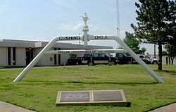
 Pipeline Crossroads of the World monument (2006) | |
| Nickname: "Pipeline Crossroads of the World" | |
 Location within Payne County and Oklahoma | |
| Coordinates: 35°58′47″N 96°45′39″W / 35.97972°N 96.76083°W | |
| Country | United States |
| State | Oklahoma |
| County | Payne |
| Area | |
| • Total | 7.60 sq mi (19.69 km2) |
| • Land | 7.59 sq mi (19.67 km2) |
| • Water | 0.01 sq mi (0.02 km2) |
| Elevation | 922 ft (281 m) |
| Population (2020) | |
| • Total | 8,327 |
| • Density | 1,096.4/sq mi (423.3/km2) |
| Time zone | UTC-6 (CST) |
| • Summer (DST) | UTC-5 (CDT) |
| ZIP code | 74023 |
| Area code | 539/918 |
| FIPS code | 40-18850[3] |
| GNIS feature ID | 2410279[2] |
| Website | www |
References
change- ↑ "ArcGIS REST Services Directory". United States Census Bureau. Retrieved September 20, 2022.
- ↑ 2.0 2.1 U.S. Geological Survey Geographic Names Information System: Cushing, Oklahoma
- ↑ "U.S. Census website". United States Census Bureau. Retrieved 2008-01-31.
- ↑ "AISRI Dictionary Database Search--prototype version. "River", Southband Pawnee". American Indian Studies Research Institute. Retrieved 2012-05-26.
- ↑ "DP1: PROFILE OF GENERAL POPULATION AND HOUSING CHARACTERISTICS". United States Census Bureau. Retrieved January 28, 2024.
Wikimedia Commons has media related to Cushing, Oklahoma.