Faiyum
city in Egypt
Faiyum[1] (Arabic: الفيوم; Coptic: ̀Ⲫⲓⲟⲙ or Ⲫⲓⲱⲙ ̀Ⲫⲓⲟⲙ or Ⲫⲓⲱⲙ) is a city in the Middle of Egypt. It is 100 kilometres (62 mi) away from Cairo. The city is located in the Faiyum Oasis, and it is the capital of Faiyum Governorate. The city was called Shedet in Ancient Egypt. When the Greeks took Egypt, they called it Crocodilopolis or Krocodilopolis. the Romans called it Arsinoë. It is one of Egypt's oldest cities, and it has a strategic location.[2]
Faiyum
الفيوم | |
|---|---|
    Clockwise from top: a fishing boat on Lake Qarun, Whale Valley, trees fighting desertification, Sobek Temple | |
 Faiyum Location within Egypt | |
| Coordinates: 29°18′30″N 30°50′39″E / 29.308374°N 30.844105°E | |
| Country | |
| Governorate | Faiyum |
| Elevation | 23 m (75 ft) |
| Population (2012) | |
| • Total | 349,883 |
| Time zone | UTC+2 (EET) |
Climate
change| Climate data for Faiyum | |||||||||||||
|---|---|---|---|---|---|---|---|---|---|---|---|---|---|
| Month | Jan | Feb | Mar | Apr | May | Jun | Jul | Aug | Sep | Oct | Nov | Dec | Year |
| Record high °C (°F) | 28 (82) |
30 (86) |
36 (97) |
41 (106) |
43 (109) |
46 (115) |
41 (106) |
43 (109) |
39 (102) |
40 (104) |
36 (97) |
30 (86) |
46 (115) |
| Average high °C (°F) | 18.9 (66.0) |
20.9 (69.6) |
24.1 (75.4) |
29 (84) |
33.6 (92.5) |
35.5 (95.9) |
36.1 (97.0) |
35.8 (96.4) |
33.2 (91.8) |
30.7 (87.3) |
25.7 (78.3) |
20.4 (68.7) |
28.7 (83.6) |
| Daily mean °C (°F) | 11.6 (52.9) |
13.2 (55.8) |
16.1 (61.0) |
20.4 (68.7) |
24.9 (76.8) |
27.1 (80.8) |
28.2 (82.8) |
28.1 (82.6) |
25.7 (78.3) |
23.1 (73.6) |
18.6 (65.5) |
13.5 (56.3) |
20.9 (69.6) |
| Average low °C (°F) | 4.3 (39.7) |
5.5 (41.9) |
8.2 (46.8) |
11.8 (53.2) |
16.3 (61.3) |
18.8 (65.8) |
20.3 (68.5) |
20.4 (68.7) |
18.2 (64.8) |
15.6 (60.1) |
11.6 (52.9) |
6.6 (43.9) |
13.1 (55.6) |
| Record low °C (°F) | 2 (36) |
4 (39) |
5 (41) |
8 (46) |
11 (52) |
16 (61) |
13 (55) |
13 (55) |
10 (50) |
11 (52) |
4 (39) |
4 (39) |
2 (36) |
| Average precipitation mm (inches) | 1 (0.0) |
1 (0.0) |
1 (0.0) |
1 (0.0) |
0 (0) |
0 (0) |
0 (0) |
0 (0) |
0 (0) |
0 (0) |
1 (0.0) |
2 (0.1) |
7 (0.1) |
| Source 1: Climate-Data.org[3] | |||||||||||||
| Source 2: Voodoo Skies[4] for record temperatures | |||||||||||||
Main sights
change- Hawara, archeological site 27 kilometres (17 mi) from the city
- Lahun Pyramids, 4 kilometres (2 mi) outside the city
- Qaitbay Mosque, in the city. the wife of the Mamluk Sultan Qaitbay built it.
- Qasr Qarun, 44 kilometres (27 mi) from the city
- Wadi Elrayan or Wadi Rayan, the largest waterfalls in Egypt, around 50 kilometres (31 mi) from the city
- Wadi Al-Hitan or Valley of whales, It is a UNESCO World Heritage Site.
Images
change-
 Qarun Palace
 -
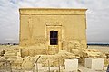
 Temple
 -
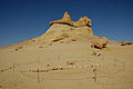 A whale skeleton at Wadi Al-Hitan (Arabic: وادي الحيتان, "Whales Valley") near Faiyum


Related pages
changeReferences
change- ↑ Planet, Lonely. "Al Fayoum travel - Lonely Planet". Lonely Planet. Archived from the original on 5 December 2017. Retrieved 3 May 2018.
- ↑ Paola Davoli (2012). "The Archaeology of the Fayum". In Riggs, Christina (ed.). The Oxford Handbook of Roman Egypt. Oxford University Press. pp. 152–153. ISBN 9780199571451.
- ↑ "Climate: Faiyum - Climate graph, Temperature graph, Climate table". Climate-Data.org. Archived from the original on 13 December 2013. Retrieved 17 August 2013.
- ↑ Voodoo Skies
Other websites
change- "Photo Gallery: Water Issues in Fayoum Villages". Archived from the original on 2009-09-06.
- Falling Rain Genomics, Inc. "Geographical information on Al Fayyum, Egypt". Retrieved 2011-03-22.
- Fayum towns and their papyri, edited with translations and notes by Bernard P. Grenfell and Arthur S. Hunt at the Internet Archive
- Vincent L. Morgan; Spencer G. Lucas (2002). "Notes From Diary––Fayum Trip, 1907". Bulletin 22. Albuquerque, New Mexico: New Mexico Museum of Natural History and Science. ISSN 1524-4156. Archived from the original (PDF) on 2009-07-20. Retrieved 2018-05-17.. 148 pages, public domain.
- Fayoum Photo Gallery Archived 2017-08-24 at the Wayback Machine