Gard
Gard is a French department in southern France in the Occitanie region and named after the Gardon river. Its prefecture is Nîmes.
Gard | |
|---|---|
 Prefecture building of the Gard department, in Nîmes | |
 Flag  Coat of arms | |
 Location of Gard in France | |
| Coordinates: 44°7′41″N 4°4′54″E / 44.12806°N 4.08167°E | |
| Country | France |
| Region | Occitanie |
| Département | 4 March 1790 |
| Prefecture | Nîmes |
| Subprefectures | Alès, Le Vigan |
| Government | |
| • President | Denis Bouad |
| Area | |
| • Total | 5,852.8 km2 (2,259.8 sq mi) |
| Population (2014)[3] | |
| • Total | 736,029 |
| • Rank | 33 |
| • Density | 130/km2 (330/sq mi) |
| Demonym | Gardois |
| Time zone | UTC+1 (CET) |
| • Summer (DST) | UTC+2 (CEST) |
| ISO 3166 code | FR-30 |
| Arrondissements | 3 |
| Cantons | 23 |
| Communes | 353 |
| Website | http://www.gard.fr/ |
History
changeGard is one of the 83 French departments made during the French revolution, on 4 March 1790. It was divided in 8 districts: Alais, Beaucaire, Nîmes, Pont-Saint-Esprit, Saint-Hippolyte, Sommières, Uzès and Le Vigan. The capital was Nîmes alternating with Alais and Uzès. In 1794, Nîmes became the only capital.[4]
With the creation of the arrondissements, the 8 districts became four arrondissements: Nîmes, Alais, Uzès and Le Vigan. In 1926, the arrondissement of Uzès was eliminated.[4]
Geography
changeGard is part of the Occitanie region, in southern France, with an area of 5,852.8 km2 (2,260 sq mi).[2]
The department borders with 6 other departments in 3 regions:
- Provence-Alpes-Côte d'Azur
- Bouches-du-Rhône (south)
- Vaucluse (east)
- Auvergne-Rhône-Alpes
- Ardèche (north)
- Occitanie
The department has a 23 km (14 mi) long coast along the Mediterranean Sea.[5]
There are 4 natural regions in Gard:[6]
- The Cévennes, a mountain chain that is part of the Massif Central. It is between the Lozère and Gard departments.
- The Garrigues, a natural region found in the Hérault and Gard departments. It is formed by hills and plateaus of limestone.
- The Costières, a natural region of the Gard department found to the south of Nîmes.
- The low region formed by the plains of the Rhone river and those along the coast.
The highest point in the department is Mont Aigoual, (44°7′17″N 03°34′53″E / 44.12139°N 3.58139°E) that is 1,565 m (5,135 ft) high[7] it is in the Cévennes mountains, on the border with the Lozère department.
The main river of Gard is the Gardon (or Gard), a right tributary of the Rhone. The Rhone flows through the eastern border of the department.
Climate
changeThe climate of the Gard department, in the city of Nîmes, is subtropical with dry-summer, Csa (Mediterranean Climate) in the Köppen climate classification.
The average temperature for the year in Nîmes, at an altitude of 60 m (200 ft), is 14.4 °C (57.9 °F). The warmest month, on average, is July with an average temperature of 23.3 °C (73.9 °F). The coolest month on average is January, with an average temperature of 6.1 °C (43.0 °F).
The average amount of precipitation for the year in Nîmes is 690.9 mm (27.2 in). The month with the most precipitation on average is October with 106.7 mm (4.2 in) of precipitation. The month with the least precipitation on average is July with an average of 25.4 mm (1.0 in).[8]
Administration
changeGard is part of the region of Occitanie. The department is managed by the Departamental Council of the Gard in Nîmes.
Administrative divisions
changeThere are 3 arrondissements (districts), 23 cantons and 353 communes (municipalities) in Gard.[9]
| INSEE code |
Arrondissement | Capital | Population[10] (2014) |
Area[11] (km²) |
Density (Inh./km²) |
Communes |
|---|---|---|---|---|---|---|
| 301 | Alès | Alès | 151,823 | 1,321.6 | 114.9 | 101 |
| 302 | Nîmes | Nîmes | 547,598 | 3,132.8 | 174.8 | 177 |
| 303 | Le Vigan | Le Vigan | 36,608 | 1,398.5 | 26.2 | 75 |
The following is a list of the 23 cantons of the Gard department (with their INSEE codes), in France, following the French canton reorganisation which came into effect in March 2015:[12]
- Aigues-Mortes (3001)
- Alès-1 (3002)
- Alès-2 (3003)
- Alès-3 (3004)
- Bagnols-sur-Cèze (3005)
- Beaucaire (3006)
- Calvisson (3007)
- La Grand-Combe (3008)
- Marguerittes (3009)
- Nîmes-1 (3010)
- Nîmes-2 (3011)
- Nîmes-3 (3012)
- Nîmes-4 (3013)
- Pont-Saint-Esprit (3014)
- Quissac (3015)
- Redessan (3016)
- Roquemaure (3017)
- Rousson (3018)
- Saint-Gilles (3019)
- Uzès (3020)
- Vauvert (3021)
- Le Vigan (3022)
- Villeneuve-lès-Avignon (3023)
Demographics
changeThe inhabitants of Gard are known, in French, as Gardois (women: Gardoises).[13]
Gard has a population, in 2014, of 736,029,[3] for a population density of 125.8 inhabitants/km2. The arrondissement of Nîmes, with 547,598 inhabitants, is by far the largest. The other two, Alès and Le Vigan, have respectively 151,823 and 36,608 inhabitants.[10]
The city with more people living in it is the capital, Nîmes (151,075). The subprefectures of Alès and Le Vigan have, respectively, 39,993 and 3,933 inhabitants.[10]
Evolution of the population in Aude

The 10 most important cities in the department are:
| City | Population[10] (2014) |
Arrondissement |
|---|---|---|
| Nîmes | 151,075 | Nîmes |
| Alès | 39,993 | Alès |
| Bagnols-sur-Cèze | 18,172 | Nîmes |
| Beaucaire | 15,859 | Nîmes |
| Saint-Gilles | 13,326 | Nîmes |
| Villeneuve-lès-Avignon | 11,716 | Nîmes |
| Vauvert | 11,353 | Nîmes |
| Pont-Saint-Esprit | 10,155 | Nîmes |
| Marguerittes | 8,577 | Nîmes |
| Uzès | 8,569 | Nîmes |
Gallery
change-
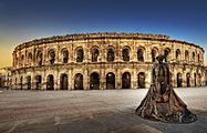 Arena of Nîmes
 -
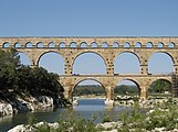 Pont du Gard bridge
 -
-
 Sautadets Waterfalls on the Cèze river


Related pages
changeReferences
change- ↑ "Le Président". Le Gard départment (in French). Archived from the original on 15 September 2016. Retrieved 9 January 2017.
- ↑ 2.0 2.1 "Comparateur de territoire Département du Gard (30)". Publications et statistiques pour la France ou les régions (in French). Institut national de la statistique et des études économiques - INSEE. Retrieved 9 January 2017.
- ↑ 3.0 3.1 "Populations légales 2014 des départements et des collectivités d'outre-mer" (in French). Institut national de la statistique et des études économiques - INSEE. Retrieved 9 January 2017.
- ↑ 4.0 4.1 "Historique du Gard". Le SPLAF (in French). Retrieved 9 January 2017.
- ↑ "Fiche d'identité". Le Gard départment (in French). Archived from the original on 15 September 2016. Retrieved 9 January 2017.
- ↑ Rolley, Jean-Pierre. "Géologie du département du Gard" (PDF). Retrieved 10 January 2017.
- ↑ ;"Mont Aigoual, France". Peakbagger.com. Retrieved 10 January 2017.
- ↑ "Nimes, France - Köppen Climate Classification". Weatherbase. Retrieved 10 January 2017.
- ↑ "Département du Gard (30)" (in French). Institut national de la statistique et des études économiques - INSEE. Retrieved 14 March 2017.
- ↑ 10.0 10.1 10.2 10.3 "Régions, départements, arrondissements, cantons et communes" (PDF). Populations légales 2014 (in French). Institut national de la statistique et des études économiques - INSEE. Retrieved 10 January 2017.
- ↑ "Département du Gard (30) et Arrondissements". Comparateur de territoire (in French). Institut national de la statistique et des études économiques - INSEE. Retrieved 10 January 2017.
- ↑ "Décret n° 2014-232 du 24 février 2014 portant délimitation des cantons dans le département du Gard" (in French). Légifrance.gouv.fr. Retrieved 10 January 2017.
- ↑ "Gard" (in French). habitants.fr. Retrieved 10 January 2017.
Other websites
change- Departamental Council website (in French)
- Prefecture website (in French)
- Région Occitanie (in French)