Gers (river)
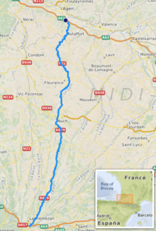
The Gers is a river in France. It flows through the Hautes-Pyrénées, Gers and Lot-et-Garonne departments, in the Occitanie and Nouvelle-Aquitaine regions. The Gers department is named after this river.
| Gers | |
|---|---|
 Gers River in Auch | |
 | |
| Location | |
| Country | France |
| Physical characteristics | |
| Source | |
| - location | Plateau de Lannemezan |
| Mouth | |
| - location | Garonne |
| - coordinates | 44°8′40″N 0°38′52″E / 44.14444°N 0.64778°E |
| Length | 175.4 km (109.0 mi) |
| Basin size | 1,227 km2 (474 sq mi) |
| Discharge | |
| - average | 7.06 m3/s (249 cu ft/s) |
| Basin features | |
| Progression | Garonne→ Atlantic Ocean Gers→ Garonne→ Atlantic Ocean |
The river's source is in the Pyrenees. It is a left tributary of the Garonne river. In general, it flows from south to north.
Geography
changeThe Gers river has a length of 175.4 kilometres (109.0 miles) and a drainage basin with an area of 1,227 square kilometres (474 square miles).[1]
Course
changeThe source of the Gers is on the Plateau de Lannemezan, in the Lannemezan commune (Hautes-Pyrénées), at an altitude of 613 metres (2,011 feet).[2]
The Gers passes through the departments and towns of:
- Hautes-Pyrénées : Lannemezan, Monléon-Magnoac
- Gers : Chélan, Panassac, Masseube, Seissan, Pavie, Auch, Preignan, Montestruc-sur-Gers, Fleurance, Lectoure
- Lot-et-Garonne : Astaffort, Layrac
The Gers river flows through 48 communes and 11 cantons.
Finally, it flows into the Garonne river to the south of Agen (Lot-et-Garonne), in the Layrac commune, at 45 metres (148 feet) of altitude.[3]
Main tributaries
change- Left tributaries
- Right tributaries
Gallery
change-
The Gers river in Sariac-Magnoac
-
Old bridge on the Gers, Pavie
-
The Gers river in Ornézan
Related pages
changeReferences
change- ↑ "Le Gers (O6--0250)" (in French). SANDRE - Portail national d'accès aux référentiels sur l'eau. Archived from the original on 3 March 2016. Retrieved 8 April 2014.
- ↑ "Source du Gers" (in French). Géoportail. Retrieved 8 April 2014.
- ↑ "Confluence du Gers" (in French). Géoportail. Retrieved 8 April 2014.
- ↑ "La Gèze (O6210530)" (in French). SANDRE - Portail national d'accès aux référentiels sur l'eau. Archived from the original on 9 February 2018. Retrieved 8 April 2014.
- ↑ "Le Cédon (O6230620)" (in French). SANDRE - Portail national d'accès aux référentiels sur l'eau. Archived from the original on 3 March 2016. Retrieved 8 April 2014.
- ↑ "Le Sousson (O62-0400)" (in French). SANDRE - Portail national d'accès aux référentiels sur l'eau. Archived from the original on 3 March 2016. Retrieved 8 April 2014.
- ↑ "Le Talouch (O6310520)" (in French). SANDRE - Portail national d'accès aux référentiels sur l'eau. Archived from the original on 3 March 2016. Retrieved 8 April 2014.
- ↑ "L'Ousse (O6330530)" (in French). SANDRE - Portail national d'accès aux référentiels sur l'eau. Archived from the original on 3 March 2016. Retrieved 8 April 2014.
- ↑ "Ruisseau de Lauze (O6340500)" (in French). SANDRE - Portail national d'accès aux référentiels sur l'eau. Archived from the original on 3 March 2016. Retrieved 8 April 2014.
- ↑ "L'Auchie (O6350600)" (in French). SANDRE - Portail national d'accès aux référentiels sur l'eau. Archived from the original on 3 March 2016. Retrieved 8 April 2014.
- ↑ "Le Cier (O6200610)" (in French). SANDRE - Portail national d'accès aux référentiels sur l'eau. Archived from the original on 3 March 2016. Retrieved 8 April 2014.
- ↑ "L'Arçon (O6300590)" (in French). SANDRE - Portail national d'accès aux référentiels sur l'eau. Archived from the original on 3 March 2016. Retrieved 8 April 2014.
- ↑ "L'Aulouste (O6320500)" (in French). SANDRE - Portail national d'accès aux référentiels sur l'eau. Archived from the original on 3 March 2016. Retrieved 8 April 2014.
Other websites
change- Banque Hydro - MEDDE, «Synthèse de la Banque Hydro - (O6372510)» Archived 2020-09-29 at the Wayback Machine (in French)