Auch
Auch (Gascon: Aush or Aux) is a commune in southwestern France, in the region of Occitanie. It is the prefecture (capital) of the Gers department. It is also the capital of 3 cantons: Auch-1, Auch-2 and Auch-3.
Auch | |
|---|---|
Prefecture and commune | |
 Cathedral in the town centre. | |
 Coat of arms | |
Location of Auch  | |
 Auch  Auch | |
| Coordinates: 43°38′47″N 0°35′08″E / 43.6465°N 0.5855°E | |
| Country | France |
| Region | Occitanie |
| Department | Gers |
| Arrondissement | Auch |
| Canton | Auch-1 Auch-2 Auch-3 |
| Intercommunality | Grand Auch |
| Government | |
| • Mayor (2014–2020) | Franck Montaugé |
| Area 1 | 72.48 km2 (27.98 sq mi) |
| Population (2012) | 21,960 |
| • Density | 300/km2 (780/sq mi) |
| Demonym(s) | Auscitain, Auscitaine |
| Time zone | UTC+01:00 (CET) |
| • Summer (DST) | UTC+02:00 (CEST) |
| INSEE/Postal code | 32013 /32000 |
| Elevation | 115–281 m (377–922 ft) (avg. 166 m or 545 ft) |
| Website | www.mairie-auch.fr |
| 1 French Land Register data, which excludes lakes, ponds, glaciers > 1 km2 (0.386 sq mi or 247 acres) and river estuaries. | |
Auch is the historical capital of Gascony and the people of this city are known, in French, as auscitain (women: auscitaines).[1]
History
change
Auch is an ancient town. The name of Auch comes from the people that inhabited the area at the time of the Roman conquest. The name of this tribe was Ausci, singular Auscus.
The Romans named the town where that tribe lived as Augusta Auscorum (or Augusta Ausciorum), which means "Augusta of the Ausci". Eventually, Augusta was dropped, and the name changed into modern Gascon Aush, and modern French Auch.
Geography
change
Auch is in the southwest of France, in Armagnac (Gascony), in the valley of the Gers river. It extends along the sides of the river that gives its name to the department.
The river splits the city in two parts:
- The Upper Town (French: Haute-Ville), on a small hill on the right side of the river. It is a medieval city with narrow streets with stairs and where most of the old monuments are found.
- The Lower Town (French: Basse-Ville), on a plain on the left side of the river.
The commune is, in straight line, at 75 km (47 mi) from the Pyrenees, 150 km (93 mi) from the Bay of Biscay, 160 km (99 mi) from Bordeaux, 70 km (43 mi) from Toulouse and 85 km (53 mi) from Pau.
It has an area of 72.48 km2 (27.98 sq mi) and its average altitude is 166 m (545 ft).

|
Auch is surrounded by the following communes, all of them part of the arrondissement of Auch: Roquelaure to the north, Preignan and Montaut-les-Créneaux to the northeast, Leboulin and Montégut to the east, Pessan to the southeast, Pavie to the south, Lasséran and Barran to the southwest, Ordan-Larroque and Duran to the west and Castin and Castillon-Massas to the northwest.
Climate
changeThe climate of the department is an oceanic climate with template summers, Cfb (Marine West Coast Climate) in the Köppen climate classification.[2]
The average temperature for the year in Auch is 13.4 °C (56.1 °F). The warmest month, on average, is July with an average temperature of 21.6 °C (70.9 °F). The coolest month on average is January, with an average temperature of 5.9 °C (42.6 °F).
The highest recorded temperature in Auch is 40.9 °C (105.6 °F), which was recorded in August. The lowest recorded temperature in Auch is −20 °C (−4 °F), which was recorded in January.
The average amount of precipitation for the year in Auch is 690.9 mm (27.2 in). The month with the most precipitation on average is May with 83.8 mm (3.3 in) of precipitation. The month with the least precipitation on average is February with an average of 30.5 mm (1.2 in).[2]
| Climate data for Auch, Gers, France | |||||||||||||
|---|---|---|---|---|---|---|---|---|---|---|---|---|---|
| Month | Jan | Feb | Mar | Apr | May | Jun | Jul | Aug | Sep | Oct | Nov | Dec | Year |
| Average high °C (°F) | 10.2 (50.4) |
11.8 (53.2) |
15.1 (59.2) |
17.6 (63.7) |
21.5 (70.7) |
25.3 (77.5) |
27.9 (82.2) |
27.9 (82.2) |
24.9 (76.8) |
19.9 (67.8) |
13.7 (56.7) |
10.4 (50.7) |
18.9 (65.9) |
| Daily mean °C (°F) | 5.9 (42.6) |
6.8 (44.2) |
9.5 (49.1) |
11.9 (53.4) |
15.8 (60.4) |
19.4 (66.9) |
21.6 (70.9) |
21.4 (70.5) |
18.5 (65.3) |
14.5 (58.1) |
9.3 (48.7) |
6.3 (43.3) |
13.4 (56.1) |
| Average low °C (°F) | 1.5 (34.7) |
1.7 (35.1) |
3.9 (39.0) |
6.2 (43.2) |
10 (50) |
13.4 (56.1) |
15.2 (59.4) |
14.9 (58.8) |
12 (54) |
9.1 (48.4) |
4.8 (40.6) |
2.1 (35.8) |
7.9 (46.3) |
| Average rainfall mm (inches) | 40.3 (1.59) |
31.6 (1.24) |
37.8 (1.49) |
61.4 (2.42) |
84.6 (3.33) |
68.4 (2.69) |
58.8 (2.31) |
64.3 (2.53) |
75 (3.0) |
72.1 (2.84) |
54.6 (2.15) |
43.1 (1.70) |
692 (27.29) |
| Source: Weatherbase.com [1] | |||||||||||||
Population
changeThe city of Auch has a population, in 2014, of 21,807;[3] its population density is of 301 inhabitants/km2.
Evolution of the population in Auch

Administration
changeAuch is the prefecture of the Cantal department, the capital of the arrondissement of Auch and the administrative centre (French: chef-lieu) of three cantons:
- Auch-1 : 5 communes + part of Auch with 11,098 inhabitants (2014)
- Auch-2 : 13 communes + part of Auch with 10,298 inhabitants (2014)
- Auch-3 : 9 communes + part of Auch with 11,390 inhabitants (2014)
It is part of the intercommunality Le Grand Auch (French: Le Grand Auch Cœur de Gascogne Agglomération).
Sister cities
changeAuch is twinned with:
Places of interest
changeA city founded by the Romans, Auch had its period of power during the Middle Ages, when it was the capital of the old province of Gascony. The high quality of the limestone is an important component of its monuments and buildings, such as its cathedral.
Some of these places of interest are:
- Cathédrale Sainte-Marie d'Auch (St Mary's Cathedral). This cathedral took 200 years to build; from the 15th – 17th centuries.
- Hôtel de ville (City hall).
- Tour d'Armagnac (Tower of Armagnac). An ancient prison from the 14th century
- Escalier monumental (Monumental Staircase). 370 steps built in 1863
- Musée des Jacobins
- Pont de la Treille
Gallery
change
-
 Auch Cathedral, west front
 -
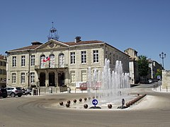 Hôtel de ville (City hall)
 -
 Tour d'Armagnac
 -
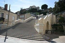 Escalier monumental
 -
 Pont de la Treille

.JPG)


Related pages
changeReferences
change- ↑ "Auch" (in French). habitants.fr. Retrieved 4 April 2014.
- ↑ 2.0 2.1 "Auch, France - Köppen Climate Classification". Weatherbase. Retrieved 4 April 2014.
- ↑ "Régions, départements, arrondissements, cantons et communes" (PDF). Populations légales 2014 (in French). Institut national de la statistique et des études économiques - INSEE. Retrieved 7 March 2017.
Other websites
change- Ville d'Auch - Official website (in French)
- Le Grand Auch (in French)
- Office de Tourisme de Grand Auch (in French)