Goolwa, South Australia
town in South Australia
Goolwa is an old port on the Murray River. It is near the Murray Mouth in South Australia.
| Goolwa South Australia | |||||||||||||||
|---|---|---|---|---|---|---|---|---|---|---|---|---|---|---|---|
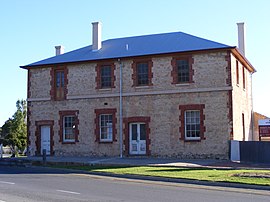
 "Australasian Hotel" building in Goolwa built in the Georgian architectural style, typical of the main street | |||||||||||||||
| Coordinates | 35°30′0″S 138°46′0″E / 35.50000°S 138.76667°E | ||||||||||||||
| Population | 2,201 (2011 census)[1] | ||||||||||||||
| Established | 1853 | ||||||||||||||
| Postcode(s) | 5214 | ||||||||||||||
| Location | 100 km (62 mi) from Adelaide | ||||||||||||||
| LGA(s) | Alexandrina Council[2] | ||||||||||||||
| Region | Fleurieu and Kangaroo Island[3] | ||||||||||||||
| State electorate(s) | Hammond[4] | ||||||||||||||
| Federal division(s) | Mayo[5] | ||||||||||||||
| |||||||||||||||
| |||||||||||||||
| Footnotes | Climate[6] Adjoining localities[2] | ||||||||||||||
References
change- ↑ Australian Bureau of Statistics (31 October 2012). "Goolwa". 2011 Census QuickStats. Retrieved 23 May 2016.
- ↑ Jump up to: 2.0 2.1 "Search result for "Goolwa (Locality Bounded)" (Record no SA0002912) with the following layers selected - "Suburbs and Localities"". Property Location Browser. Government of South Australia. Archived from the original on 12 October 2016. Retrieved 23 May 2016.
- ↑ "Fleurieu Kangaroo Island SA Government region" (PDF). The Government of South Australia. Archived from the original (PDF) on 21 March 2019. Retrieved 17 April 2017.
- ↑ "District of Hammond Background Profile". Electoral Commission SA. Retrieved 29 April 2016.
- ↑ "Federal electoral division of Mayo, boundary gazetted 16 December 2011" (PDF). Australian Electoral Commission. Retrieved 2 August 2015.
- ↑ "Monthly climate statistics: Summary statistics HINDMARSH ISLAND AWS (nearest station)". Commonwealth of Australia , Bureau of Meteorology. Retrieved 29 April 2016.
Wikimedia Commons has media related to Goolwa, South Australia.
