Hacienda Heights, California
census-designated place in Los Angeles County, California, United States
Hacienda Heights is an unincorporated suburban community in Los Angeles County, California, United States.
Hacienda Heights, California | |
|---|---|
 The view of Hacienda Heights, with Hsi Lai Temple and Puente Hills in the background | |
| Nickname: The Heights | |
| Motto: "Growing with Pride" [1] | |
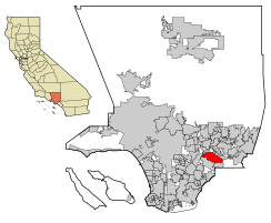
 Location of Hacienda Heights in Los Angeles County, California. | |
| Coordinates: 34°0′2″N 117°58′10″W / 34.00056°N 117.96944°W | |
| Country | United States |
| State | California |
| County | Los Angeles |
| Area | |
| • Total | 11.182 sq mi (28.962 km2) |
| • Land | 11.175 sq mi (28.944 km2) |
| • Water | 0.007 sq mi (0.018 km2) 0.06% |
| Elevation | 453 ft (138 m) |
| Population (2020)[3] | |
| • Total | 54,191 |
| • Density | 4,800/sq mi (1,900/km2) |
| Time zone | UTC-8 (PST) |
| • Summer (DST) | UTC-7 (PDT) |
| ZIP code | 91745 |
| Area code(s) | 626, 562 |
| FIPS code | 06-31596 |
References
change- ↑ Tedford, Daniel (4 June 2009). "'Growing' with pot … er pride". InsideSocal. Archived from the original on 20 December 2016. Retrieved December 17, 2016.
- ↑ U.S. Census
- ↑ "QuickFacts: Hacienda Heights CDP, California". United States Census Bureau. Retrieved August 28, 2023.


