Isle (river)
The Isle (Occitan: Eila) is a river of south-western France that flows through the Haute-Vienne, Dordogne and Gironde departments, in the Nouvelle-Aquitaine region. It is a right tributary of the Dordogne river.
| Isle | |
|---|---|
 Isle River in Périgueux | |
  | |
| Location | |
| Country | France |
| Physical characteristics | |
| Source | |
| - location | Plateau de Millevaches |
| Mouth | |
| - location | Dordogne |
| - coordinates | 44°54′56″N 0°14′57″W / 44.91556°N 0.24917°W |
| Length | 255 km (158 mi) |
| Basin size | 7,700 km2 (3,000 sq mi) |
| Discharge | |
| - average | 90 m3/s (3,200 cu ft/s) |
| Basin features | |
| Progression | Dordogne→ Gironde estuary→ Atlantic Ocean |
Geography
changeThe Isle has a length of 255.3 km (158.6 mi), and a drainage basin with an area of approximately 7,510 km2 (2,900 sq mi).[1]
Its average yearly discharge (volume of water which passes through a section of the river per unit of time) is 61.7 cubic metres per second at Coutras.[2]
Course
changeThe Isle starts on the Monts du Limousin, part of the Massif Central, in the commune of Janailhac, Haute-Vienne department, at an elevation of about 379 m (1,243 ft).[3]
It flows generally southwest through the Haute-Vienne, Dordogne and Gironde departments before flowing into the Dordogne river in Libourne at about 5 m (16 ft) of altitude.[4]
The Isle flows through 2 regions, 3 departments and 66 communes.[1] The main communes are:
Main tributaries
changeThe main tributaries (more than 50 km long) of the Isle river are:
Gallery
change-
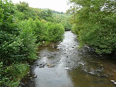 The Isle river in Jumilhac-le-Grand
 -
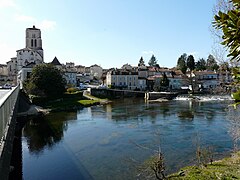
 The Isle river in Périgueux
 -
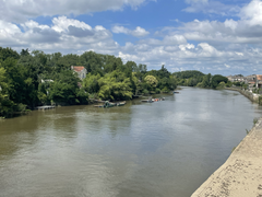
 The Isle river in Saint-Astier
 -
 The Isle river in Libourne

.JPG)


Related pages
changeReferences
change- ↑ 1.0 1.1 "L'Isle (P---0150)" (in French). SANDRE - Portail national d'accès aux référentiels sur l'eau. Archived from the original on 22 May 2012. Retrieved 17 April 2015.
- ↑ "L'Isle à Coutras" (in French). Banque Hydro. Archived from the original on 1 May 2015. Retrieved 17 April 2015.
- ↑ "Source de l'Isle" (in French). Géoportail. Retrieved 17 April 2015.
- ↑ "Confluence de l'Isle" (in French). Géoportail. Retrieved 17 April 2015.
- ↑ "La Loue (P61-0400)" (in French). SANDRE - Portail national d'accès aux référentiels sur l'eau. Archived from the original on 4 March 2016. Retrieved 17 April 2015.
- ↑ "L'Auvézère (P6--0250)" (in French). SANDRE - Portail national d'accès aux référentiels sur l'eau. Archived from the original on 3 March 2016. Retrieved 17 April 2015.
- ↑ "La Dronne (P7--0250)" (in French). SANDRE - Portail national d'accès aux référentiels sur l'eau. Archived from the original on 3 March 2016. Retrieved 17 April 2015.
- ↑ "Le Lary (P80-0400)" (in French). SANDRE - Portail national d'accès aux référentiels sur l'eau. Retrieved 17 April 2015.
Other websites
change- Banque Hydro - Station P9001510 - L'Isle à Coutras Archived 2015-02-19 at the Wayback Machine (in French)