M-185 (Michigan highway)
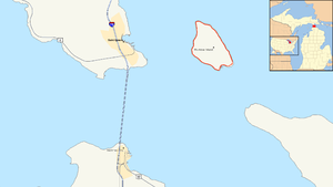
M-185 is a state highway in the U.S. state of Michigan. It circles Mackinac Island. Mackinac Island is a popular tourist place on the Lake Huron side of the Straits of Mackinac. The highway is along the island's coast. The highway is a thin paved road that is 8.004 miles (12.881 km) long. There are scenic views of the straits that divide the Upper and the Lower peninsulas of Michigan. It also has views of Lakes Huron and Michigan. It doesn't connect to any other Michigan state highways. This is because it is on an island. People can only get to it by passenger ferry.
 Map of the Straits of Mackinac with M-185 highlighted in red | ||||
| Route information | ||||
| Length | 8.004 mi[1] (12.881 km) | |||
| Existed | July 12, 1933[2]–present | |||
| Restrictions | Pedestrians, bicycles or horses only | |||
| Major junctions | ||||
| Loop around Mackinac Island | ||||
| Fort Street British Landing Road | ||||
| Location | ||||
| Country | United States | |||
| State | Michigan | |||
| Counties | Mackinac | |||
| Highway system | ||||
| ||||
The Michigan Department of Transportation (MDOT) says that the M-185 is "the only state highway in the nation where motor vehicles are banned".[3] Traffic on it is by foot, on horse, by horse-drawn vehicle, or by bicycle. Cars have been banned on the island since the 1890s. Only a few vehicles have been allowed on the island other than the city's emergency vehicles. The highway was built during the first decade of the 20th century by the state. It was designated as a state highway in 1933. The highway was paved in the 1950s. Parts were rebuilt to deal with coastal erosion in the 1980s. Until an accident in 2005, it was the only state highway without any car accidents.
Major intersections
changeThe highway is on Mackinac Island. That island is in Mackinac County. Milemarkers are posted in a counterclockwise way.[4]
| mi[1] | km | Destinations | Notes |
|---|---|---|---|
| 0.000 | 0.000 | Fort Street | Endpoint used for milemarkers |
| 4.552 | 7.326 | British Landing Road | Leads to interior of the island; British Landing |
| 7.607 | 12.242 | Market Street | Leads to many signposted historic sites in the downtown area |
| 8.004 | 12.881 | Fort Street | Endpoint used for milemarkers |
| 1.000 mi = 1.609 km; 1.000 km = 0.621 mi | |||
References
change- ↑ 1.0 1.1 Michigan Department of Transportation & Michigan Center for Shared Solutions and Technology Partnerships (2009). MDOT Physical Reference Finder Application (Map). Michigan Department of Transportation. Retrieved September 4, 2010.
- ↑ Michigan Department of Transportation & V3 Consultants (February 13, 2001). "Mackinac County" (Map). Right-of-Way File Application. Scale not given. Lansing: Michigan Department of Transportation. Sheet 76.
{{cite map}}: CS1 maint: numeric names: authors list (link) - ↑ Michigan Department of Transportation (November 3, 2005). "Road & Highway Facts". History and Culture. Michigan Department of Transportation. Retrieved March 17, 2008.
- ↑ Mackinac Island Tourism Bureau (2009). Tourism Bureau Map of Mackinac Island (PDF) (Map). 1:8,600 and 1:4,100. Cartography by Christopher J. Bessert. Mackinac Island, MI: Mackinac Island Tourism Bureau. OCLC 648133817. Archived from the original (PDF) on May 28, 2008. Retrieved June 1, 2009.
