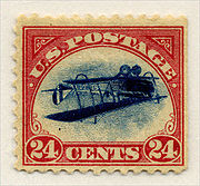
Postage stamp
Postage stamps are pieces of paper which signal that payment has been made for the item to be mailed.

1. Image
2. Perforations
3. Denomination
4. Country name

These days they have adhesive on the back. They are put on the top right-hand corner of an envelope. They pay the fee for having the postal service take the envelope to where it is being sent.
The idea was British, and the first postage stamps were issued in Britain in the mid-nineteenth century. On 1 May 1840, the Penny Black, the first adhesive postage stamp, was issued in the United Kingdom.
There are a lot of different postage stamps in the world. Most countries have their own stamps. People collect them in books called stamp albums. Sometimes, the stamps all have errors in the printing like in the "Inverted Jenny" picture with the aeroplane printed upside down.
People on stamps
changePeople on stamps is one more common topic in stamp collecting. For instance, many famous people are featured on stamps in the United States.
- Examples of people on U.S. stamps
Maps on stamps
changeMaps on stamps is a common topic on stamp collecting. Almost every country has featured maps on stamps. There are also topic maps including demographic and cross topic ones (showing explorer routes over maps).
- Examples of maps on stamps
-
Nature conservation and world map on a Russian postage stamp
-
Coat of Arms "Bayern" and Germany map
-
"Eire", 1922 Ireland
Related pages
changeOther websites
changewww.cpaphil.com Thousands of Postage stamps, covers and Vintage postcards
- The dictionary definition of postage stamp at Wiktionary