Mauriac, Cantal
Mauriac is a commune in south central France in the region of Auvergne-Rhône-Alpes. It is a subprefecture of the Cantal department. It is also the capital of the arrondissement of the same name.
Mauriac | |
|---|---|
 Notre-Dame-des-Miracles basilica | |
 Coat of arms | |
Location of Mauriac  | |
 Mauriac  Mauriac | |
| Coordinates: 45°13′11″N 2°20′03″E / 45.2197°N 2.3342°E | |
| Country | France |
| Region | Auvergne-Rhône-Alpes |
| Department | Cantal |
| Arrondissement | Mauriac |
| Canton | Mauriac |
| Intercommunality | Pays de Mauriac |
| Government | |
| • Mayor (2014-2020) | Gérard Leymonie[1] |
| Area 1 | 27.61 km2 (10.66 sq mi) |
| Population (2014) | 3,682 |
| • Density | 130/km2 (350/sq mi) |
| Demonym | Mauriacois |
| Time zone | UTC+01:00 (CET) |
| • Summer (DST) | UTC+02:00 (CEST) |
| INSEE/Postal code | 15120 /15200 |
| Elevation | 351–760 m (1,152–2,493 ft) (avg. 722 m or 2,369 ft) |
| Website | www.mauriac.fr |
| 1 French Land Register data, which excludes lakes, ponds, glaciers > 1 km2 (0.386 sq mi or 247 acres) and river estuaries. | |
History
changeMauriac is one of the oldest town in the Cantal department founded about 2,000 years ago.[2]
The town grew around the Saint-Pierre de Mauriac monastery and the Notre-Dame-des-Miracles Basilica.
Geography
changeMauriac is in the northwest of Cantal, close to the border with the Corrèze department, near the Dordogne river. It is along the Auze river, a left tributary of the Dordogne.
Mauriac is in hilly terrain, with the main populated area at an altitude of about 350–450 m (1,150–1,480 ft), while the surrounding areas rise to about 760 m (2,490 ft) in the volcanic foothills. The commune has an area of 27.61 km2 (10.66 sq mi).
The commune of Mauriac is surrounded by the communes Le Vigean, Brageac, Escorailles, Ally, Salins, Jaleyrac, Chaussenac, Sourniac, Drugeac, Chalvignac, Anglards-de-Salers and Méallet.

|
Climate
changeThe climate of Mauriac, in the Köppen climate classification, is Cfb - Oceanic climate with template summers.
Population
changeThe inhabitants of Mauriac are known, in French, as Mauriacois (women: Mauriacoises).[3]
With a population of 3,682,[4] Mauriac has a population density of 133 inhabitants/km2.
Evolution of the population in Mauriac

Mauriac forms with Le Vigean the urban area of Mauriac, one of the seven urban areas of Cantal, with a population of 4,559 inhabitants (2013) and an area of 56.6 km2 (21.9 sq mi).[5] This urban area is the centre of the metropolitan area of Mauriac, formed by five communes with a population of 5,277 inhabitants and an area of 93.9 km2 (36.3 sq mi).[6]
Administration
changeMauriac is a subprefecture of the Cantal department, the capital of the arrondissement of Mauriac and the administrative centre (French: chef-lieu) of the canton of Mauriac.
It is part of the intercommunality Pays de Mauriac (French: Communauté de communes du Pays de Mauriac).
Sites of interest
change- Notre-Dame-des-Miracles Basilica.
- Saint-Pierre de Mauriac; ruins of a monastery built in the 12th century.
- Hôtel d'Orcet, built in the 18th century; the headquarters of the subprefecture are here now.
Gallery
change-
 Notre-Dame-des-Miracles basilica.
 -
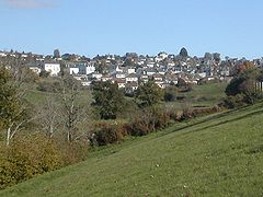 Mauriac from the Val St-Jean lake.
 -
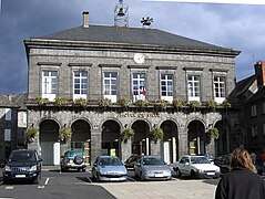 Mauriac town hall.
 -
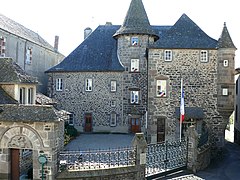 Subprefecture in the former Hôtel d'Orcet


Related pages
changeReferences
change- ↑ "Les élus" (in French). Ville de Mauriac. Archived from the original on 28 December 2016. Retrieved 25 January 2017.
- ↑ "Histoire et patrimonie" (in French). Ville de Mauriac. Retrieved 25 January 2017.[permanent dead link]
- ↑ "Mauriac (15200)" (in French). habitants.fr. Retrieved 25 January 2017.
- ↑ "Régions, départements, arrondissements, cantons et communes" (PDF). Populations légales 2014 (in French). Institut national de la statistique et des études économiques - INSEE. Retrieved 25 January 2017.
- ↑ "Unité urbaine de Mauriac (15105)". Comparateur de territoire (in French). Institut national de la statistique et des études économiques - INSEE. Retrieved 25 January 2017.
- ↑ "Aire urbaine de Mauriac (577)". Comparateur de territoire (in French). Institut national de la statistique et des études économiques - INSEE. Retrieved 25 January 2017.
Other websites
change- City Council website (in French)
- Communauté de communes du Pays de Mauriac[permanent dead link] (in French)
- Pays de Mauriac Tourism Office Archived 2016-03-20 at the Wayback Machine