McLean County, Illinois
county in Illinois, United States
McLean County is the largest county by land area in the U.S. state of Illinois. According to the 2020 census, it had a population of 170,954.[1] Its county seat is Bloomington.[2]
McLean County | |
|---|---|
 Old McLean County Courthouse | |
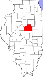
 Location within the U.S. state of Illinois | |
 Illinois's location within the U.S. | |
| Coordinates: 40°29′N 88°51′W / 40.49°N 88.85°W | |
| Country | |
| State | |
| Founded | December 25, 1830 |
| Named for | John McLean |
| Seat | Bloomington |
| Largest city | Bloomington |
| Area | |
| • Total | 1,186 sq mi (3,070 km2) |
| • Land | 1,183 sq mi (3,060 km2) |
| • Water | 2.9 sq mi (8 km2) 0.2% |
| Population | |
| • Total | 170,954 |
| • Density | 140/sq mi (56/km2) |
| Time zone | UTC−6 (Central) |
| • Summer (DST) | UTC−5 (CDT) |
| Website | www |
McLean County was founded in 1830 and named for John McLean, United States Senator for Illinois, who died in 1830.[3]
Geography
changeThe county has a total area of 1,186 square miles (3,070 km2).
Bordering counties
change- Woodford County - northwest
- Livingston County - northeast
- Ford County - east
- Champaign County - southeast
- Piatt County - south
- DeWitt County - south
- Logan County - southwest
- Tazewell County - west
Communities
changeCities
changeTown
changeVillages
changeCensus-designated place
changeOther unincorporated communities
change- Barnes
- Bentown
- Bloomington Heights
- Cropsey
- Covell
- Funks Grove
- Holder
- Lyttleville
- Meadows
- Merna
- Shirley
- Watkins
- Weedman
- Weston
Townships
changeMcLean County is divided into these townships:
Ghost towns
change- Allin
- Benjaminville
- Kumler
References
change- ↑ 1.0 1.1 "QuickFacts: McLean County, Illinois". United States Census Bureau. Retrieved August 14, 2023.
- ↑ "Find a County". National Association of Counties. Archived from the original on May 31, 2011. Retrieved 2011-06-07.
- ↑ Gannett, Henry (1905). The Origin of Certain Place Names in the United States. U.S. Government Printing Office. p. 194.
Other websites
changeWikimedia Commons has media related to McLean County, Illinois.