Morristown, New Jersey
town in Morris County, New Jersey, United States
Morristown is a town of Morris County in the state of New Jersey, United States. About 20,180 people were living in Morristown as of the year 2020. It is the county seat of Morris County. Morristown has an area of 3 square miles. During the American Revolutionary War it was twice the winter quarters of George Washington and his Continental Army.
Morristown, New Jersey | |
|---|---|
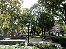
 Morristown Green, a historic park, in Morristown | |
| Nickname(s): "Military Capital of the American Revolution", "Mo Town", "The Mo", "Mo City" | |
 Location of Morristown in Morris County highlighted in red (right). Inset map: Location of Morris County in New Jersey highlighted in orange (left). | |
 | |
| Coordinates: 40°47′48″N 74°28′38″W / 40.796562°N 74.477318°W[1][2] | |
| Country | |
| State | |
| County | |
| Founded | 1715 |
| Incorporated | April 6, 1865 |
| Government | |
| • Type | Mayor–Council (Faulkner Act) |
| • Body | Town Council |
| Area | |
| • Total | 3.01 sq mi (7.79 km2) |
| • Land | 2.91 sq mi (7.53 km2) |
| • Water | 0.10 sq mi (0.25 km2) 3.26% |
| • Rank | 333rd of 565 in state 25th of 39 in county[1] |
| Elevation | 315 ft (96 m) |
| Population | |
| • Total | 20,180 |
| • Rank | 137th of 565 in state 9th of 39 in county[8] |
| • Density | 6,937.1/sq mi (2,678.4/km2) |
| • Rank | 67th of 565 in state 2nd of 39 in county[8] |
| Time zone | UTC−05:00 (Eastern (EST)) |
| • Summer (DST) | UTC−04:00 (Eastern (EDT)) |
| ZIP Codes | 07960–07963[9] |
| Area code(s) | 862/973 and 201[10][11] |
| FIPS code | 3402748300[1][12][13] |
| GNIS feature ID | 0885309[1][14] |
| Website | www |
References
change- ↑ 1.0 1.1 1.2 1.3 2019 Census Gazetteer Files: New Jersey Places, United States Census Bureau. Accessed July 1, 2020.
- ↑ US Gazetteer files: 2010, 2000, and 1990, United States Census Bureau. Accessed September 4, 2014.
- ↑ 2012 New Jersey Legislative District Data Book, Rutgers University Edward J. Bloustein School of Planning and Public Policy, March 2013, p. 116.
- ↑ "ArcGIS REST Services Directory". United States Census Bureau. Retrieved October 11, 2022.
- ↑ "Town of Morristown". Geographic Names Information System. United States Geological Survey. Retrieved March 8, 2013.
- ↑ QuickFacts Morristown town, New Jersey, United States Census Bureau. Accessed December 26, 2022.
- ↑ Total Population: Census 2010 - Census 2020 New Jersey Municipalities, New Jersey Department of Labor and Workforce Development. Accessed December 1, 2022.
- ↑ 8.0 8.1 Population Density by County and Municipality: New Jersey, 2020 and 2021, New Jersey Department of Labor and Workforce Development. Accessed March 1, 2023.
- ↑ Look Up a ZIP Code, United States Postal Service. Accessed September 4, 2011.
- ↑ Area Code Lookup - NPA NXX for Convent Station, NJ, Area-Codes.com. Accessed September 6, 2014.
- ↑ "Area Code Lookup (NPA NXX)".
- ↑ U.S. Census website, United States Census Bureau. Accessed September 4, 2014.
- ↑ Geographic Codes Lookup for New Jersey, Missouri Census Data Center. Accessed April 1, 2022.
- ↑ US Board on Geographic Names, United States Geological Survey. Accessed September 4, 2014.
Other websites
changeWikimedia Commons has media related to Morristown, New Jersey.
