Orbetello
Orbetello is a town and commune in the province of Grosseto (Tuscany), Italy. It is about 35 km (22 mi) south of Grosseto, on a lagoon, which is an important Natural Reserve.
Orbetello | |
|---|---|
| Comune di Orbetello | |
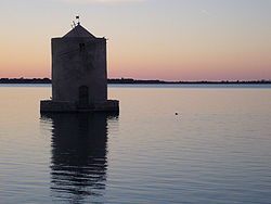
 The windmill on the lagoon of Orbetello. | |
| Coordinates: 42°26′34″N 11°13′29″E / 42.44278°N 11.22472°E | |
| Country | Italy |
| Region | Tuscany |
| Province | Grosseto (GR) |
| Frazioni | Albinia, Ansedonia, Fonteblanda, Giannella, Talamone |
| Government | |
| • Mayor | Altero Matteoli (since 2006-05-29) |
| Area | |
| • Total | 226.98 km2 (87.64 sq mi) |
| Elevation | 3 m (10 ft) |
| Population (2004-12-31)[2] | |
| • Total | 14,946 |
| • Density | 66/km2 (170/sq mi) |
| Demonym | Orbetellani |
| Time zone | UTC+1 (CET) |
| • Summer (DST) | UTC+2 (CEST) |
| Postal code | 58010, 58015 |
| Dialing code | 0564 |
| Patron saint | Saint Blaise |
| Saint day | february 3 |
| Website | www.comune.orbetello.gr.it |

History
changeOrbetello was an ancient Etruscan village, which in 280 BC went under the control of the Romans, who had founded their colony of Cosa.
In the Middle Ages it was controlled by the Aldobrandeschi family, who held it until the 14th century, when it was bought by the city of Orvieto. After some years, Orbetello was captured by the Sienese Republic. In the mid-16th century it was part of the Spanish puppet State of Presides, becoming its capital. Later it was under the Grand Duchy of Tuscany and, from the late 19th century, the new Kingdom of Italy.
In 1927-1933, Italo Balbo's "air cruises" started from Orbetello's lagoon.
Important monuments and places
change- The city walls (5th century BC).
- Cathedral of Santa Maria Assunta, built over an Etruscan-Roman temple and half re-built in 1375.
- The Spanish Forte delle Saline, in the frazione of Albinia.
- Remains of the Roman city of Cosa in the frazione of Ansedonia.
- Ruins of the Monastery of Sant'Angelo.
References
change- ↑ "Superficie di Comuni Province e Regioni italiane al 9 ottobre 2011". Italian National Institute of Statistics. Retrieved 16 March 2019.
- ↑ "Popolazione Residente al 1° Gennaio 2018". Italian National Institute of Statistics. Retrieved 16 March 2019.


