Oxted
town and civil parish in Surrey, England
Oxted is a town and civil parish in the Tandridge district of Surrey, England. It is near the North Downs.
| Oxted | |
|---|---|
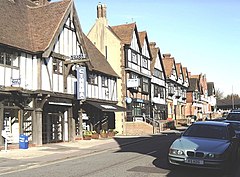
 The timber-framed stucco façades of buildings in Oxted | |
| Location within Surrey | |
| Area | 15.15 km2 (5.85 sq mi) |
| Population | 11,314 (civil parish as of 2011)[1] 13,452 (built-up area)[2] |
| • Density | 747/km2 (1,930/sq mi) |
| OS grid reference | TQ3953 |
| • London | 17.9 mi (28.8 km) |
| Civil parish |
|
| District | |
| Shire county | |
| Region | |
| Country | England |
| Sovereign state | United Kingdom |
| Post town | Oxted |
| Postcode district | RH8 |
| Dialling code | 01883 |
| Police | Surrey |
| Fire | Surrey |
| Ambulance | South East Coast |
| UK Parliament | |
It is about 9 miles (14 km) south-east of Croydon, 9 miles (14 km) west of Sevenoaks, and 9 miles (14 km) north of East Grinstead.
References
change- ↑ Key Statistics; Quick Statistics: Population Density Archived 11 February 2003 at the Wayback Machine United Kingdom Census 2011 Office for National Statistics Retrieved 21 November 2013
- ↑ "Custom report - Nomis - Official Labour Market Statistics". Archived from the original on 1 December 2021. Retrieved 4 February 2019.
