Paraná River
The Paraná River is a river in south Central South America. It goes through Brazil, Paraguay and Argentina. It is 4,880 kilometres (3,030 mi) long.[3] It is second in length only to the Amazon River among South American rivers. The name Paraná is a shortened form of the phrase "para rehe onáva". It is a Tupi word that means "like the sea".
| Paraná River Parana (Guarani) Rio Paraná, Río Paraná | |
|---|---|
 Paraná River seen from Zárate, Buenos Aires Province, Argentina | |
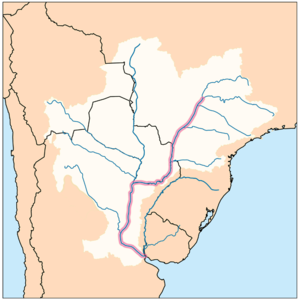
 Map of the Paraná River Basin, showing the Paraná River in highlight | |
| Location | |
| Countries | |
| Region | South America |
| Physical characteristics | |
| Source | Paranaíba River |
| - location | Rio Paranaíba, Minas Gerais, Brazil |
| - coordinates | 19°13′21″S 46°10′28″W / 19.22250°S 46.17444°W[1] |
| - elevation | 1,148 m (3,766 ft) |
| 2nd source | Rio Grande |
| - location | Bocaina de Minas, Minas Gerais, Brazil |
| - coordinates | 22°9′56″S 44°23′38″W / 22.16556°S 44.39389°W |
| Source confluence | Paranaíba and Rio Grande |
| - coordinates | 20°5′12″S 51°0′2″W / 20.08667°S 51.00056°W |
| Mouth | Rio de la Plata |
| - location | Atlantic Ocean, Argentina, Uruguay |
| - coordinates | 34°0′5″S 58°23′37″W / 34.00139°S 58.39361°W[2] |
| - elevation | 0 m (0 ft) |
| Length | 4,880 km (3,030 mi)[3] |
| Basin size | 2,582,672 km2 (997,175 sq mi) |
| Discharge | |
| - location | Paraná Delta, Rio de La Plata |
| - average | (Period 1971-2010)
19,706 m3/s (695,900 cu ft/s)[4] 17,290 m3/s (611,000 cu ft/s)[3] 667 km3/a (21,100 m3/s)[5] |
| - minimum | 2,450 m3/s (87,000 cu ft/s) |
| - maximum | 65,000 m3/s (2,300,000 cu ft/s) |
| Discharge | |
| - location | Corrientes (Basin size 1,950,000 km2 (750,000 sq mi)[4] |
| - average | 18,979 m3/s (670,200 cu ft/s)[4] |
| Discharge | |
| - location | Itaí (Basin size 953,950 km2 (368,320 sq mi) |
| - average | 13,916 m3/s (491,400 cu ft/s)[4] |
| Discharge | |
| - location | Itaipú (Basin size 826,691 km2 (319,187 sq mi) |
| - average | 11,746 m3/s (414,800 cu ft/s)[4] |
| Discharge | |
| - location | Porto Primavera (Basin size 574,379 km2 (221,769 sq mi) |
| - average | 7,938 m3/s (280,300 cu ft/s)[4] |
| Basin features | |
| River system | Río de la Plata |
| Tributaries | |
| - left | Iguaçu, Piquiri, Ivaí, Paranapanema, Tietê, Rio Grande |
| - right | Salado, Paraguay, Ivinhema, Pardo, Paranaiba |
It starts where the Paranaiba and Grande rivers join in southern Brazil. It joins the Paraguay River and continues south, where it merges with Uruguay River, before flowing into the Atlantic Ocean.
The surubí and the sábalo are fished on the river.
There are many dams along the river. The Yacyretá and Itaipu are used for hydroelectric power.
References change
- ↑ "Monitoramento da Qualidade das Águas Superficiais da Bacia do Río Paranaíba: Relatório Annual 2007". Governo do Estado de Minas Gerais, Instituto Mineiro de Gestão das Águas. 2008. Archived from the original (PDF in ZIP) on 6 July 2011. Retrieved 12 August 2010.
- ↑ Río Paraná Guazú at GEOnet Names Server (main distributary)
- ↑ 3.0 3.1 3.2 "Río de la Plata". Encyclopædia Britannica. Retrieved 11 August 2010.
- ↑ 4.0 4.1 4.2 4.3 4.4 4.5 "Balance hídrico en la Cuenca del Plata". Archived from the original on 2021-10-19. Retrieved 2022-11-02.
- ↑ "Transboundary River Basin Overview – La Plata" (PDF).