Province of Fermo
The Province of Fermo (Italian: Provincia di Fermo) is a province in the Marche region of Italy. Its capital is the city of Fermo.
Province of Fermo
Provincia di Fermo | |
|---|---|
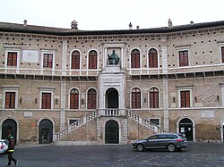
 The Palazzo dei Prori in Fermo | |
 Map with the province of Fermo, in red, in Italy | |
| Coordinates: 43°9′37.51″N 13°43′5.16″E / 43.1604194°N 13.7181000°E | |
| Country | |
| Region | Marche |
| Capital | Fermo |
| Comuni | 40 |
| Government | |
| • President | Aronne Perugini[1] |
| Area | |
| • Total | 862.77 km2 (333.12 sq mi) |
| Population (1 January 2017)[3] | |
| • Total | 174,849 |
| • Density | 200/km2 (520/sq mi) |
| Time zone | UTC+1 (CETU) |
| • Summer (DST) | UTC+2 (CEST) |
| Postal code | 63900 |
| Telephone prefix | 0734, 0736 |
| Vehicle registration | FM |
| ISTAT | 109 |
| Website | Official website |
It is a province since 2004 with parts of the province of Ascoli Piceno but it was in 2009 when it became an active province.
Geography
changeFermo has an area of 862.77 km2 (333 sq mi), the smallest province of the Marche region.[2] The province is surrounded, by land, by two provinces of Marcheː the province of Macerata in the north and west and the province of Ascoli Piceno in the south; to the east is the Adriatic Sea on the east.
The main rivers in the province, from north to south, are (all of them flow to the east into tfe Adriatic Sea but Ete Morto)ː
- Chienti - 91 km long; its mouth is near Civitanova Marche.
- Tenna - 70 km long; its mouth is near Porto Sant'Elpidio.
- Ete Morto - 40 km long; it is a tributary of the Chienti river.
- Ete Vivo 35 km long; its mouth is near Porto San Giorgio.
- Aso - 63 km long; its mouth is near Pedaso.
The highest mountain in the province is Monte Priora,(42°55′56″N 13°14′26″E / 42.93222°N 13.24056°E) in the Apennines; it is 2,332 m (7,651 ft) high.[4]
Population
changeThere are 174,849 persons living in the province (1 January 2017),[3] for a population density of 202.7 inhabitants/km².
Evolution of the population

Municipalities
changeThere are 40 municipalities (or comuni) in the province; they are:
- Altidona
- Amandola
- Belmonte Piceno
- Campofilone
- Falerone
- Fermo
- Francavilla d'Ete
- Grottazzolina
- Lapedona
- Magliano di Tenna
- Massa Fermana
- Monsampietro Morico
- Montappone
- Monte Giberto
- Monte Rinaldo
- Monte San Pietrangeli
- Monte Urano
- Monte Vidon Combatte
- Monte Vidon Corrado
- Montefalcone Appennino
- Montefortino
- Montegiorgio
- Montegranaro
- Monteleone di Fermo
- Montelparo
- Monterubbiano
- Montottone
- Moresco
- Ortezzano
- Pedaso
- Petritoli
- Ponzano di Fermo
- Porto San Giorgio
- Porto Sant'Elpidio
- Rapagnano
- Sant'Elpidio a Mare
- Santa Vittoria in Matenano
- Servigliano
- Smerillo
- Torre San Patrizio
The largest comune is Fermo, with 124.53 km2 (48 sq mi) and the smallest is Pedaso, with 3.85 km2 (1 sq mi). The comune with fewest people living in it is Smerillo with 366 inhabitants.
Main comuni
changeThe following table shows the 10 comuni with more inhabitants with their population,[3] and their area and altitude.[5]
| No. | Comune | Population (2017) |
Area (km²) |
Density | Altitude (m) |
|---|---|---|---|---|---|
| 1 | Fermo | 37,396 | 124.53 | 300.3 | 319 |
| 2 | Porto Sant'Elpidio | 26,270 | 18.13 | 1,449.0 | 4 |
| 3 | Sant'Elpidio a Mare | 17,073 | 50.52 | 337.9 | 251 |
| 4 | Porto San Giorgio | 16,066 | 8.79 | 1,827.8 | 4 |
| 5 | Montegranaro | 12,925 | 31.42 | 411.4 | 279 |
| 6 | Monte Urano | 8,280 | 16.72 | 495.2 | 247 |
| 7 | Montegiorgio | 6,789 | 47.45 | 143.1 | 411 |
| 8 | Amandola | 3,624 | 69.50 | 52.1 | 500 |
| 9 | Altidona | 3,411 | 12.97 | 263.0 | 224 |
| 10 | Grottazzolina | 3,382 | 9.26 | 365.2 | 227 |
Gallery
change-
Piazza del Popolo, Fermo.
-
Cathedral of Fermo.
-
Villa Castellano, Porto Sant'Elpidio.
-
Sant'Elpidio a Mare.
Related pages
changeReferences
change- ↑ "Presidente" (in Italian). Provincia di Fermo. Retrieved 26 June 2016.
- ↑ 2.0 2.1 "Provincia di Fermo" (in Italian). Tuttitalia.it. Retrieved 26 June 2016.
- ↑ 3.0 3.1 3.2 "Statistiche demografiche ISTAT" (in Italian). Demo.istat.it. Archived from the original on 3 January 2018. Retrieved 1 November 2017.
- ↑ "Monte Priora, Italy". Peakbagger.com. Retrieved 4 July 2017.
- ↑ "Comuni in provincia di Fermo per popolazione" (in Italian). Tuttitalia.it. Retrieved 4 July 2017.
