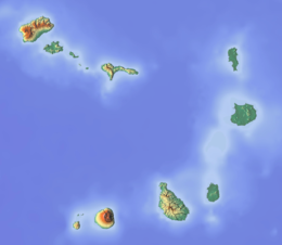
São Nicolau, Cape Verde
island of Cape Verde
São Nicolau is an island of Cape Verde. It is one of the Barlavento group. In 2015, about 12,400 people lived there.[1] The main towns are Ribeira Brava and Tarrafal de São Nicolau.
Native name: Saniclau Nickname: Ilha de Chiquinho | |
|---|---|
 | |
| Geography | |
| Location | Atlantic Ocean |
| Coordinates | 16°36′54″N 24°16′16″W / 16.615°N 24.271°W |
| Area | 343 km2 (132 sq mi) |
| Length | 44.5 km (27.65 mi) |
| Width | 22.0 km (13.67 mi) |
| Highest elevation | 1,312 m (4304 ft) |
| Highest point | Monte Gordo |
| Administration | |
| Concelhos (Municipalities) | Ribeira Brava, Tarrafal de São Nicolau |
| Largest settlement | Ribeira Brava |
| Demographics | |
| Population | 12,424[1]: 36 (2015) |
| Pop. density | 36.2/km2 (93.8/sq mi) |
The island was discovered in 1461 or 1462 by Diogo Afonso, together with the islands of São Vicente and Santo Antão.[2]
References
change- ↑ 1.0 1.1 Cabo Verde, Statistical Yearbook 2015, Instituto Nacional de Estatística
- ↑ Valor simbólico do centro histórico da Praia, Lourenço Conceição Gomes, Universidade Portucalense, 2008
Wikimedia Commons has media related to São Nicolau (Cape Verde).
