San Mateo, California
city in San Mateo County, California, United States
San Mateo (/ˌsæn məˈteɪ.oʊ/ SAN mə-TAY-oh; Spanish for "Saint Matthew") is a city in San Mateo County, California, United States, in the San Francisco Bay Area. With a population of about 100,000 (105,661 at the 2020 census), it is one of the larger suburbs on the San Francisco Peninsula, located between Burlingame to the north, Foster City to the east, Belmont to the south, and Highlands-Baywood Park and Hillsborough to the west. San Mateo was incorporated in 1864.
San Mateo, California | |
|---|---|
|
Top: aerial view of San Mateo; middle: downtown (left) and Draper University (right); bottom: downtown (left) and Bay Meadows (right). | |
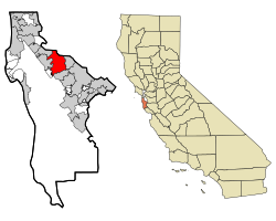
 Location in San Mateo County and the state of California | |
| Coordinates: 37°33′15″N 122°18′47″W / 37.55417°N 122.31306°W | |
| Country | United States |
| State | California |
| County | San Mateo |
| Incorporated | September 4, 1894[1] |
| Named for | St. Matthew |
| Area | |
| • Total | 15.85 sq mi (41.04 km2) |
| • Land | 12.13 sq mi (31.42 km2) |
| • Water | 3.71 sq mi (9.62 km2) 23.63% |
| Elevation | 46 ft (14 m) |
| Population | |
| • Total | 105,661 |
| • Rank | 68th in California 298th in the United States |
| • Density | 8,711/sq mi (3,363/km2) |
| Time zone | UTC−8 (Pacific) |
| • Summer (DST) | UTC−7 (PDT) |
| ZIP codes[5] | 94401–94404, 94497 |
| Area code | 650 |
| FIPS code | 06-68252 |
| GNIS feature IDs | 1659584, 2411800 |
| Website | www |
References
change- ↑ "California Cities by Incorporation Date" (Word). California Association of Local Agency Formation Commissions. Retrieved January 13, 2017.
- ↑ "2019 U.S. Gazetteer Files". United States Census Bureau. Retrieved July 1, 2020.
- ↑ "San Mateo". Geographic Names Information System. United States Geological Survey. Retrieved December 3, 2014.
- ↑ "QuickFacts: San Mateo city, California". United States Census Bureau. Retrieved August 26, 2023.
- ↑ "ZIP Code(tm) Lookup". United States Postal Service. Retrieved December 3, 2014.
Other websites
changeMedia related to San Mateo, California at Wikimedia Commons


