Sanday, Orkney
island in the north of the Orkney Islands, Scotland, UK
Sanday is one of the inhabited islands of Orkney, Scotland. It covers an area of 50.43 square kilometres (19.5 sq mi).[3] It is the third largest of the Orkney Islands.[8] The main centres of population are Lady Village and Kettletoft. Sanday can be reached by Orkney Ferries or plane from Kirkwall on the Orkney Mainland. Cultural activities revolve around the school.
| Norse name | Sandey[1][2] |
|---|---|
| Meaning of name | Old Norse: sand island[3] |
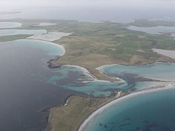
 An aerial view of the southern coast of Sanday, looking west. Tres Ness and Conninghole are in the foreground. | |
| Location | |
Sanday shown within Orkney | |
| OS grid reference | 25 |
| Coordinates | 59°15′N 2°33′W / 59.25°N 2.55°W |
| Physical geography | |
| Island group | Orkney |
| Area | 5,043 ha (19.5 sq mi)[3] |
| Area rank | 21 [5] |
| Highest elevation | 20 m (66 ft)[4] |
| Administration | |
| Sovereign state | United Kingdom |
| Country | Scotland |
| Council area | Orkney Islands |
| Demographics | |
| Population | 478[4] |
| Population rank | 22 [5] |
| Population density | 9.8 people/km2[3][6] |
| Largest settlement | Lady |
| References | [7] |
Climate
change| Climate data for Sanday airfield, 14m amsl, 1981-2010, extremes 1973-present | |||||||||||||
|---|---|---|---|---|---|---|---|---|---|---|---|---|---|
| Month | Jan | Feb | Mar | Apr | May | Jun | Jul | Aug | Sep | Oct | Nov | Dec | Year |
| Record high °C (°F) | 12.2 (54.0) |
14.5 (58.1) |
20.0 (68.0) |
21.0 (69.8) |
22.0 (71.6) |
23.0 (73.4) |
25.0 (77.0) |
25.0 (77.0) |
26.0 (78.8) |
18.3 (64.9) |
16.0 (60.8) |
12.8 (55.0) |
26.0 (78.8) |
| Average high °C (°F) | 6.4 (43.5) |
6.4 (43.5) |
7.6 (45.7) |
9.5 (49.1) |
12.0 (53.6) |
14.0 (57.2) |
15.9 (60.6) |
16.0 (60.8) |
14.1 (57.4) |
11.4 (52.5) |
8.6 (47.5) |
6.8 (44.2) |
10.7 (51.3) |
| Average low °C (°F) | 1.9 (35.4) |
1.7 (35.1) |
2.4 (36.3) |
3.8 (38.8) |
5.6 (42.1) |
8.1 (46.6) |
10.2 (50.4) |
10.3 (50.5) |
8.8 (47.8) |
6.7 (44.1) |
4.2 (39.6) |
2.3 (36.1) |
5.5 (41.9) |
| Record low °C (°F) | −6.0 (21.2) |
−13.0 (8.6) |
−13.9 (7.0) |
−11.5 (11.3) |
−2.1 (28.2) |
1.0 (33.8) |
3.4 (38.1) |
3.7 (38.7) |
0.5 (32.9) |
−10.8 (12.6) |
−6.5 (20.3) |
−9.0 (15.8) |
−13.9 (7.0) |
| Average rainfall mm (inches) | 109.7 (4.32) |
93.3 (3.67) |
95.7 (3.77) |
60.3 (2.37) |
48.0 (1.89) |
52.7 (2.07) |
57.4 (2.26) |
66.3 (2.61) |
96.0 (3.78) |
95.3 (3.75) |
126.0 (4.96) |
107.8 (4.24) |
1,008.5 (39.69) |
| Average rainy days (≥ 1.0 mm) | 20.1 | 16.8 | 17.9 | 13.4 | 10.6 | 10.7 | 11.6 | 12.5 | 16.2 | 19.6 | 20.8 | 18.5 | 188.7 |
| Mean monthly sunshine hours | 32.2 | 59.3 | 98.2 | 136.8 | 190.0 | 148.6 | 132.2 | 129.7 | 105.3 | 75.8 | 40.1 | 24.5 | 1,172.7 |
| Source 1: Met Office for averages[9] | |||||||||||||
| Source 2: Voodoo Skies for extremes except February high,[10] Weather Underground for the remaining extreme[11] | |||||||||||||
References
changeWikimedia Commons has media related to Sanday, Orkney Islands.
- ↑ Orkney Placenames Archived 2000-08-30 at the Wayback Machine. Orkneyjar. Retrieved 15 November 2014.
- ↑ Anderson (1873) p. 176
- ↑ 3.0 3.1 3.2 3.3 Haswell-Smith (2004) p. 392
- ↑ 4.0 4.1 "www.orkneyislands.info - A complete visitor's guide - Sanday". orkneyislands.info. Archived from the original on 22 August 2015. Retrieved 10 September 2015.
- ↑ 5.0 5.1 Area and population ranks: there are c. 300 islands over 20 ha in extent and 93 permanently inhabited islands were listed in the 2011 census.
- ↑ National Records of Scotland (15 August 2013) (pdf) Statistical Bulletin: 2011 Census: First Results on Population and Household Estimates for Scotland - Release 1C (Part Two) Archived 2014-02-23 at the Wayback Machine. "Appendix 2: Population and households on Scotland’s inhabited islands". Retrieved 17 August 2013.
- ↑ Pedersen, Roy (January 1992) Orkneyjar ok Katanes (map, Inverness, Nevis Print)
- ↑ Haswell-Smith (2004) p. 334
- ↑ "Sanday Airfield climate". metoffice.gov.uk. Retrieved 10 September 2015.
- ↑ "Orkney Monthly Temperature". Voodoo Skies. Archived from the original on March 4, 2016.
{{cite web}}: CS1 maint: unfit URL (link) - ↑ "Weather - Personal Weather Station: IORKNEYS2 by Wunderground.com - Weather Underground". wunderground.com. Retrieved 15 September 2015.
