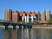
Sha Tin
Sha Tin, also spelt Shatin, is a satellite town along Shing Mun River in Sha Tin District of East New Territories, Hong Kong. Administratively, it is part of the Sha Tin District. It is one of Hong Kong's most prominent examples of new town developments in the 1970s. Together with its satellite town Ma On Shan, Shatin is the most populous city in the New Territories, with a 2011 population census of 630,273 within an area of 35.87 km2 (13.85 sq mi). It is in the southern half of New Territories East below Tolo Harbour, it is the principal city of Sha Tin District, which is the second most populous district of the territory.
Sha Tin
沙田 | |
|---|---|
 Shing Mun River Promenade | |
| Coordinates: 22°22′30″N 114°11′00″E / 22.37500°N 114.18333°E | |
| Country | |
| Region | New Territories |
| District | Sha Tin District |
| New town | 1973 |
| Administrative complex | Sha Tin Government Offices |
| Government | |
| • Type | Local council |
| • Chairman | Ho Hau-cheung |
| Area | |
| • City | 35.87 km2 (13.85 sq mi) |
| Population (2010) | |
| • City | 630,000 |
| • Urban | 630,000 |
| Demonym | Shatinian |
| Time zone | UTC+8 (Hong Kong Time) |
| Mean solar time UTC+08 | |
| Sha Tin | |||||||||
 | |||||||||
| Chinese | 沙田 | ||||||||
|---|---|---|---|---|---|---|---|---|---|
| Literal meaning | Sandy Field | ||||||||
| |||||||||
| Lek Yuen | |||||||||
| Traditional Chinese | 瀝源 | ||||||||
| Literal meaning | Source of Trickling | ||||||||
| |||||||||
| Shatin New Town | |||||||||
| Traditional Chinese | 沙田新市鎮 | ||||||||
| Literal meaning | Shatin New Town | ||||||||
| |||||||||
The city was founded in 1973 under the New Towns Development Programme of the Hong Kong government. Its current name was named after the nearby village of Sha Tin Wai. Housing the industrial area of Fo Tan, Shatin's economy once heavily relied on manufacturing, logistics and transportation. Since the late 1990s, it has undergone an extensive transition into areas such as business, service, tourism, entertainment, culture, education, sports, technology and scientific research. This has been marked by the building of Sha Tin Racecourse, Hong Kong Sports Institute and the Hong Kong Science Park in its outskirts.
Geography
changeSha Tin is in a valley, on both sides of the Shing Mun River, running from the southwest to the northeast. It is bordered by Tai Wai in the southwest and by Fo Tan (left bank) and Shek Mun (right bank) in the northeast.
Cross-border activities
changeBecause they are close to the Shenzhen border, towns in the northern parts of Hong Kong, notably Sheung Shui and Yuen Long, have become hubs for parallel traders who have been buying up large quantities of goods, forcing up local prices and disrupting the daily lives of local citizens.[1][2] Since 2012, there has been an increase in mainland parallel traders arriving in the North District of Hong Kong to re-export infant formula and household products – goods popular with mainlanders – across the border to Shenzhen.[3] The volume of smuggling activity spilled over into Tuen Mun and Sha Tin in 2014.
The first anti-parallel trading protest was started at Sheung Shui in September 2012.[4] As government efforts to limit the adverse impact of mainland trafficking were widely seen as inadequate, so there have been further subsequent protests in towns in the North District including Sha Tin.[5][6]
References
change- ↑ "近百名人到上水示威不滿內地水貨客". now.com. 15 September 2012. Retrieved 29 October 2014.
- ↑ Ma, Mary (10 February 2015). "Parallel lines of concern need fixing"[permanent dead link]. The Standard
- ↑ Jennifer, Ngo "Milk powder supplies still not meeting needs". South China Morning Post. 24 January 2014. Retrieved 29 October 2014
- ↑ Luk, Eddie (21 September 2012). "Seeing red (white and blue)" Archived 2015-03-11 at Archive.today. The Standard
- ↑ Wong, Hilary; Cheng, Kevin (9 March 2015). "Targeting mainlanders ... young and old" Archived 2015-04-02 at the Wayback Machine. The Standard
- ↑ "Hong Kong Protests Against Day Trippers as China Eyes Action". Bloomberg L.P.
