Ukhta
Ukhta (Russian: Ухта́; Komi: Уква, Ukva) is an important industrial town in the Komi Republic, Russia. It was known as Chibyu before 1939.
Ukhta
Ухта | |
|---|---|
| Other transcription(s) | |
| • Komi | Уква |
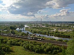
 View of Ukhta from Vetlosyan | |
| Coordinates: 63°34′N 53°42′E / 63.567°N 53.700°E | |
| Country | Russia |
| Federal subject | Komi Republic[1] |
| Founded | 1929 |
| Town status since | 1943 |
| Government | |
| • Mayor | Grigory Konenkov |
| Area | |
| • Total | 13,200 km2 (5,100 sq mi) |
| Elevation | 100 m (300 ft) |
| Population | |
| • Total | 99,591 |
| • Rank | 166th in 2010 |
| • Density | 7.5/km2 (20/sq mi) |
| • Subordinated to | town of republic significance of Ukhta[1] |
| • Capital of | town of republic significance of Ukhta[1] |
| • Urban okrug | Ukhta Urban Okrug[3] |
| • Capital of | Ukhta Urban Okrug[3] |
| Time zone | UTC+3 (MSK |
| Postal code(s)[5] | 169300 |
| Dialing code(s) | +7 8216[6] |
| OKTMO ID | 87725000001 |
| Twin towns | Naryan-Mar |
| Website | mouhta |
History
changeUkhta was founded in 1929 as an oil drilling village. It was given town status in 1943. As well as a link to the Pechora Railway, Ukhta has a small airport. The town was used in the gulag in the 1940s and 1950s by the Soviet Union.
Economy
changeUkhta is located in the Timan-Pechora Basin, a major oil and gas-producing region in the Komi Republic. Its oilfields are located to the south of the town. Most of the town's oil is refined in oil refineries in Moscow and Saint Petersburg, although some is refined locally.
Climate
changeUkhta has a subarctic climate (Köppen: Dfc) with long, cold winters and short, warm summers. Winters in Ukhta are less extreme compared to areas at a similar latitude in Siberia, although still very cold from a European point of view.
| Climate data for Ukhta | |||||||||||||
|---|---|---|---|---|---|---|---|---|---|---|---|---|---|
| Month | Jan | Feb | Mar | Apr | May | Jun | Jul | Aug | Sep | Oct | Nov | Dec | Year |
| Record high °C (°F) | 2.5 (36.5) |
3.0 (37.4) |
13.0 (55.4) |
23.8 (74.8) |
30.1 (86.2) |
33.5 (92.3) |
35.2 (95.4) |
32.5 (90.5) |
27.4 (81.3) |
20.0 (68.0) |
8.2 (46.8) |
3.6 (38.5) |
35.2 (95.4) |
| Average high °C (°F) | −13.1 (8.4) |
−10.9 (12.4) |
−2.4 (27.7) |
4.6 (40.3) |
12.0 (53.6) |
19.0 (66.2) |
22.1 (71.8) |
17.3 (63.1) |
10.7 (51.3) |
2.8 (37.0) |
−6.0 (21.2) |
−10.6 (12.9) |
3.8 (38.8) |
| Daily mean °C (°F) | −16.5 (2.3) |
−14.7 (5.5) |
−6.8 (19.8) |
−0.5 (31.1) |
6.3 (43.3) |
13.3 (55.9) |
16.5 (61.7) |
12.4 (54.3) |
6.9 (44.4) |
0.4 (32.7) |
−8.9 (16.0) |
−13.8 (7.2) |
−0.5 (31.1) |
| Average low °C (°F) | −20.0 (−4.0) |
−18.1 (−0.6) |
−10.9 (12.4) |
−5.0 (23.0) |
1.5 (34.7) |
8.2 (46.8) |
11.6 (52.9) |
8.4 (47.1) |
4.0 (39.2) |
−1.8 (28.8) |
−11.3 (11.7) |
−17.2 (1.0) |
−4.2 (24.4) |
| Record low °C (°F) | −48.5 (−55.3) |
−43.9 (−47.0) |
−39.2 (−38.6) |
−28.4 (−19.1) |
−16.9 (1.6) |
−4.2 (24.4) |
−0.4 (31.3) |
−3.9 (25.0) |
−8.8 (16.2) |
−26.4 (−15.5) |
−37.8 (−36.0) |
−49.0 (−56.2) |
−49.0 (−56.2) |
| Average precipitation mm (inches) | 32 (1.3) |
26 (1.0) |
29 (1.1) |
28 (1.1) |
44 (1.7) |
66 (2.6) |
71 (2.8) |
69 (2.7) |
54 (2.1) |
55 (2.2) |
40 (1.6) |
39 (1.5) |
553 (21.8) |
| Source: Weatherbase[7] | |||||||||||||
Notable people
change- Roman Abramovich, Russian businessman
- Dmitri Aliev, Olympic figure skater
- Aleksandr Chupriyan, Minister of Emergency Situations
- Olga Fonda, actress
- Sergei Kapustin, hockey player
- Viktor Alexandrovič Lyapkalo, painter
- Eduard Rossel, Governor of Sverdlovsk Oblast
- Yulia Samoilova, Russian singer
- Alexander Sukhorukov, Olympic swimmer
- Arsen Pavlov, Former commander of Donetsk Seperatist militia "Sparta Battalion"
References
change- ↑ 1.0 1.1 1.2 1.3 Law #16-RZ
- ↑ Всероссийская перепись населения 2010 года. Том 1 [2010 All-Russian Population Census, vol. 1]. Всероссийская перепись населения 2010 года (2010 All-Russia Population Census) (in Russian). Federal State Statistics Service. 2011. Retrieved June 29, 2012.
- ↑ 3.0 3.1 Law #11-RZ
- ↑ "Об исчислении времени". Официальный интернет-портал правовой информации (in Russian). 3 June 2011. Retrieved 19 January 2019.
- ↑ Почта России. Информационно-вычислительный центр ОАСУ РПО. (Russian Post). Поиск объектов почтовой связи (Postal Objects Search) (in Russian)
- ↑ "dialing codes ref".
- ↑ "Ukhta, Russia Travel Weather Averages". Weatherbase. 2013. Archived from the original on 2021-11-29. Retrieved 2022-09-19. Retrieved on February 19, 2013.


