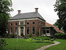
Westerwolde
municipality in the province of Groningen, the Netherlands
Westerwolde, Low Saxon: Westerwoolde, is a municipality of the Province of Groningen, the Netherlands. It lies in the southeast of Groningen.
Westerwolde | |
|---|---|
 Bellingwolde | |
| Coordinates: 52°56′48.7″N 7°08′46.3″E / 52.946861°N 7.146194°E | |
| Country | |
| Province | |
| Government | |
| • Mayor | Jaap Velema |
| Area | |
| • Total | 275.7 km2 (106.4 sq mi) |
| Population (January 1, 2001) | |
| • Total | 26,151 |
| • Density | 94.85/km2 (245.7/sq mi) |
| Time zone | UTC+01:00 (CET) |
| Postal code | 9540–9564, 9566–9569, 9695–9699 |
| Area code | 0597, 0599 |
| Website | Official website |
The municipality was established on January 1, 2018. It was made by combining the former municipalities of Bellingwedde and Vlagtwedde.
About 25,000 people live in Westerwolde. It covers an area of about 281 square kilometres (108 square miles).
The main settlement is Sellingen.
Other websites
changeMedia related to Westerwolde (municipality) at Wikimedia Commons
- Official website (in Dutch)


