Agly
The Agly River (Catalan: Aglí, Occitan: Aglin) is a river in southern France. It flows mostly to the southeast through the Plain of Roussillon, in the region of Occitanie. It ends in the Mediterranean Sea.
| Agly | |
|---|---|
 | |
  | |
| Location | |
| Country | France |
| Physical characteristics | |
| Source | |
| - location | Corbières Massif |
| Mouth | |
| - location | Mediterranean Sea |
| - coordinates | 42°46′44″N 3°2′20″E / 42.77889°N 3.03889°E |
| Length | 80 km (50 mi) |
| Basin size | 903 km2 (349 sq mi) |
| Discharge | |
| - average | 6.31 m3/s (223 cu ft/s) |
On its way to the Mediterranean Sea, it flows through the departments of Aude and Pyrénées-Orientales.
Geography
changeThe Agly river is 81.7 kilometres (50.8 miles) long.[1] Its source is on the Pass of Linas, to the northeast of the Pech de Bugarach, the highest of the Corbières mountains, departments of Aude, at an elevation of 940 metres (3,084 feet).
It then goes into the Pyrénées-Orientales by the gorges of Galamus and flows into the Mediterranean Sea south of Barcarès.
There is a dam on the Agly river, on Caramany, Pyrénées-Orientales; it was built to prevent floods and to store water.

Hydrology
changeThe Agly is a very irregular small river. Its flow was observed over a period of 42 years (1967-2008) in Estagel about twenty kilometers from its mouth and after receiving the waters of its tributary Verdouble.[2]
The discharge of the river at this location is 6.31 cubic metres (223 cubic feet) per second.
The Agly shows typical seasonal fluctuations like other small rivers in southern France. The highest levels of the river are in winter and spring, from December to May inclusive, with the highest level in February. They are followed by a rapid fall in the flow during the low water period that goes from late June to early October.
Tributaries
changeThe Angly has 19 tributaries;[1] the main ones are:
- Right tributaries:
- Boulzane, 34 kilometres (21 miles)
- Désix, 32.4 kilometres (20.1 miles)
- Left tributaries
- Maury, 18.6 kilometres (11.6 miles)
- Verdouble, 46.8 kilometres (29.1 miles)
- Robou, 17.8 kilometres (11.1 miles)
Departments and towns along the river
change
Landmarks
changeGallery
change-
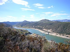
 The dam on the Agly river, at Caramany
 -
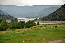
 The lake at Caramany during a dry season
 -
 The Gorges of Galamus
 -
 The aqueduct of Ansignan


References
change- ↑ 1.0 1.1 "Fiche cours d'eau - L'Agly (Y06-0400)" (in French). SANDRE - Portail national d'accès aux référentiels sur l'eau. 1 January 2006. Archived from the original on 23 April 2012. Retrieved 11 July 2013.
- ↑ "hydro.eaufrance.fr (Station: Y0664040, Option: Synthèse)". Archived from the original on 2015-02-19. Retrieved 2013-07-20.
Other websites
change- Station: Y0664060, Option: Synthèse Archived 2015-02-19 at the Wayback Machine (in French)