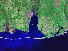
Barrier island
coastal landform and a type of dune system
Barrier islands are landforms which are flat or lumpy areas of sand. It is formed by waves and tides. They usually occur in chains. It can consist from a few islands to more than a dozen. They can change during storms and other actions. The longest and widest barrier island is Padre Island of Texas.[1]

References
change- ↑ Garrison, J. R.; Williams, J.; Potter Miller, S.; Weber, E. T.; McMechan, G.; Zeng, X. (2010-04-01). "Ground-Penetrating Radar Study of North Padre Island: Implications for Barrier Island Internal Architecture, Model for Growth of Progradational Microtidal Barrier Islands, and Gulf of Mexico Sea-Level Cyclicity". Journal of Sedimentary Research. 80 (4): 303–319. Bibcode:2010JSedR..80..303G. doi:10.2110/jsr.2010.034. ISSN 1527-1404.