Chamberlain, South Dakota
city in and county seat of Brule County, South Dakota, United States
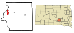
Chamberlain is a city in the central part of the U.S. state of South Dakota. It is the county seat of Brule County, and it is located along the Missouri River, across from Oacoma. It became a city in 1881,[6] and 2,473 people lived there at the 2020 census.[3]
Chamberlain, South Dakota | |
|---|---|
 The Akta Lakota Museum in Chamberlain | |
| Motto: "One day just isn't enough..." | |
 Location in Brule County and the state of South Dakota | |
| Coordinates: 43°48′20″N 99°19′42″W / 43.80556°N 99.32833°W | |
| Country | United States |
| State | South Dakota |
| County | Brule |
| Founded | 1881[1] |
| Area | |
| • Total | 5.67 sq mi (14.70 km2) |
| • Land | 4.48 sq mi (11.60 km2) |
| • Water | 1.20 sq mi (3.10 km2) |
| Elevation | 1,404 ft (428 m) |
| Population | |
| • Total | 2,473 |
| • Density | 552.13/sq mi (213.16/km2) |
| Time zone | UTC−6 (Central (CST)) |
| • Summer (DST) | UTC−5 (CDT) |
| ZIP codes | 57325-57326 |
| Area code | 605 |
| FIPS code | 46-11220[4] |
| GNIS feature ID | 1265153[5] |
| Website | www |
References
change- ↑ "SD Towns" (PDF). South Dakota State Historical Society. Archived from the original (PDF) on 2010-02-10. Retrieved 2010-02-11.
- ↑ "ArcGIS REST Services Directory". United States Census Bureau. Retrieved October 15, 2022.
- ↑ 3.0 3.1 "Profile of General Population and Housing Characteristics: 2020 Demographic Profile Data (DP-1): Chamberlain city, South Dakota". United States Census Bureau. Retrieved February 14, 2024.
- ↑ "U.S. Census website". United States Census Bureau. Retrieved 2008-01-31.
- ↑ "US Board on Geographic Names". United States Geological Survey. 2007-10-25. Retrieved 2008-01-31.
- ↑ "SD Towns" (PDF). South Dakota State Historical Society. Retrieved 2013-11-16.
Other websites
change- City of Chamberlain website Archived 2013-11-13 at the Wayback Machine