Charleston County, South Carolina
county in South Carolina, United States
Charleston County is a county in the U.S. state of South Carolina. As of the 2020 census, 408,235 people lived there,[1] making it the third-most populous county in South Carolina (after Greenville and Richland counties). Its county seat is Charleston.[2] The county was formed in 1901.
Charleston County | |
|---|---|
 Charleston County Courthouse | |
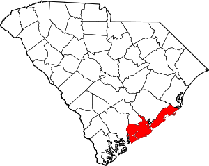
 Location within the U.S. state of South Carolina | |
 South Carolina's location within the U.S. | |
| Coordinates: 32°48′02″N 79°56′33″W / 32.800458°N 79.94248°W | |
| Country | |
| State | |
| Founded | January 1, 1800 |
| Named for | King Charles II |
| Seat | Charleston |
| Largest community | Charleston |
| Area | |
| • Total | 1,357.99 sq mi (3,517.2 km2) |
| • Land | 917.98 sq mi (2,377.6 km2) |
| • Water | 440.01 sq mi (1,139.6 km2) 32.40% |
| Population (2020) | |
| • Total | 408,235 |
| • Density | 444.71/sq mi (171.70/km2) |
| Time zone | UTC−5 (Eastern) |
| • Summer (DST) | UTC−4 (EDT) |
| Congressional districts | 1st, 6th |
| Website | www |
Geography
change| Historical population | |||
|---|---|---|---|
| Census | Pop. | %± | |
| 1790 | 66,985 | — | |
| 1800 | 57,480 | −14.2% | |
| 1810 | 63,179 | 9.9% | |
| 1820 | 80,212 | 27.0% | |
| 1830 | 86,338 | 7.6% | |
| 1840 | 82,661 | −4.3% | |
| 1850 | 72,805 | −11.9% | |
| 1860 | 70,100 | −3.7% | |
| 1870 | 88,863 | 26.8% | |
| 1880 | 102,800 | 15.7% | |
| 1890 | 59,903 | −41.7% | |
| 1900 | 88,006 | 46.9% | |
| 1910 | 88,594 | 0.7% | |
| 1920 | 108,450 | 22.4% | |
| 1930 | 101,050 | −6.8% | |
| 1940 | 121,105 | 19.8% | |
| 1950 | 164,856 | 36.1% | |
| 1960 | 216,382 | 31.3% | |
| 1970 | 247,650 | 14.5% | |
| 1980 | 276,974 | 11.8% | |
| 1990 | 295,039 | 6.5% | |
| 2000 | 309,969 | 5.1% | |
| 2010 | 350,209 | 13.0% | |
| 2020 | 408,235 | 16.6% | |
| U.S. Decennial Census[3] 1790–1960[4] 1900–1990[5] 1990–2000[6] 2010–2020[1] | |||
According to the U.S. Census Bureau, the county has a total area of 1,358 square miles (3,520 km2), of which 916 square miles (2,370 km2) is land and 442 square miles (1,140 km2) (33%) is water.[7] It is the largest county in South Carolina by total land and water area. It is along the Atlantic coast.
Bordering counties
change- Berkeley County - north
- Georgetown County - northeast
- Colleton County - west
- Dorchester County - northwest
Communities
changeCities
change- Charleston (county seat) (partly in Berkeley County)
- Folly Beach
- Isle of Palms
- North Charleston (partly in Dorchester County and Berkeley County)
Towns
changeCensus-designated place
change- Adams Run
- Ladson (partly in Berkeley County)
Unincorporated communities
change- Edisto Island (partly in Colleton County)
- Johns Island
References
change- ↑ 1.0 1.1 "QuickFacts: Charleston County, South Carolina". United States Census Bureau. Retrieved January 20, 2024.
- ↑ National Association of Counties. "NACo County Explorer". Retrieved January 20, 2024.
- ↑ "U.S. Decennial Census". United States Census Bureau. Retrieved March 16, 2015.
- ↑ "Historical Census Browser". University of Virginia Library. Archived from the original on August 11, 2012. Retrieved March 16, 2015.
- ↑ Forstall, Richard L., ed. (March 27, 1995). "Population of Counties by Decennial Census: 1900 to 1990". United States Census Bureau. Retrieved March 16, 2015.
- ↑ "Census 2000 PHC-T-4. Ranking Tables for Counties: 1990 and 2000" (PDF). United States Census Bureau. April 2, 2001. Archived (PDF) from the original on 2022-10-09. Retrieved March 16, 2015.
- ↑ "2010 Census Gazetteer Files". United States Census Bureau. August 22, 2012. Retrieved March 16, 2015.
Other websites
changeWikimedia Commons has media related to Charleston County, South Carolina.