Chesapeake Bay
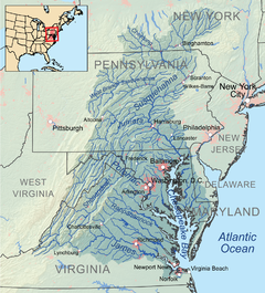
The Chesapeake Bay (pronounced /'tʃɛsəpi:k/) is the largest estuary in the United States.[3] It lies off the Atlantic Ocean and is surrounded by Maryland and Virginia. The bay's watershed covers 64,299 square miles (166,534 km2) in the District of Columbia and parts of six states: New York, Pennsylvania, Delaware, Maryland, Virginia, and West Virginia.[3] More than 150 rivers and streams drain into it.
| Chesapeake Bay | |
|---|---|
 The Chesapeake Bay – Landsat satellite image | |
 Chesapeake Bay Watershed - extends north/east/west into six adjoining American states - Maryland, Virginia, West Virginia, Delaware, Pennsylvania, and New York state, plus the federal capital city of Washington in the District of Columbia. | |
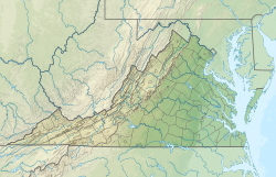
| Location | Maryland, Virginia |
| Coordinates | 37°48′N 76°06′W / 37.8°N 76.1°W |
| Type | Estuary |
| Etymology | Chesepiooc, Algonquian for village "at a big river" |
| Primary inflows | Susquehanna River mouth east of Havre de Grace, Maryland |
| River sources | Deer Creek, Bush River, Gunpowder River, Back River, Patapsco River, Severn River, Patuxent River, Potomac River, Rappahannock River, York River, James River, Chester River, Choptank River, Nanticoke River, Pocomoke River |
| Primary outflows | Atlantic Ocean north of Virginia Beach, Virginia 36°59′45″N 75°57′34″W / 36.99583°N 75.95944°W |
| Catchment area | 64,299 sq mi (166,530 km2) |
| Basin countries | United States |
| Max. length | 200 mi (320 km) |
| Max. width | 30 mi (48 km) |
| Surface area | 4,479 sq mi (11,600 km2) |
| Average depth | 21 ft (6.4 m) |
| Residence time | 180 days [note 1] |
| Settlements | Annapolis, Baltimore, Cambridge, Cape Charles, Chesapeake, Chesapeake Beach, Elkton, Hampton, Havre de Grace, Newport News, Norfolk, Portsmouth, Virginia Beach |
| References | |
| Official name | Chesapeake Bay Estuarine Complex |
| Designated | 4 June 1987 |
| Reference no. | 375[2] |
The Chesapeake Bay is about 200 miles (300 km) long, from the Susquehanna River in the north to the Atlantic Ocean. At its narrowest point between Kent County's Plum Point (near Newtown) and the Harford County shore near Romney Creek, the bay isabout 2.8 miles (4.5 km) wide. At the widest location, it is 30 miles (50 km) wide. The bay is 46 feet (14 m) deep on average.
The bay has two bridges over it. The Chesapeake Bay Bridge crosses the bay in Maryland from Sandy Point (near Annapolis) to Kent Island. The Chesapeake Bay Bridge-Tunnel in Virginia connects Virginia Beach to Cape Charles.
Notes change
References change
- ↑ Du, Jiabi; Shen, Jian (2016). "Water residence time in Chesapeake Bay for 1980–2012". Journal of Marine Systems. 164. Elsevier BV: 101–111. Bibcode:2016JMS...164..101D. doi:10.1016/j.jmarsys.2016.08.011. ISSN 0924-7963.
- ↑ "Chesapeake Bay Estuarine Complex". Ramsar Sites Information Service. Retrieved 25 April 2018.
- ↑ 3.0 3.1 "Fact Sheet 102-98 - The Chesapeake Bay: Geologic Product of Rising Sea Level". U. S. Geological Survey. 1998-11-18. Retrieved 2008-01-13.
Other websites change
Media related to Chesapeake Bay at Wikimedia Commons
- Saving The Chesapeake Bay Archived 2007-09-30 at the Wayback Machine
- Chesapeake Bay Foundation
