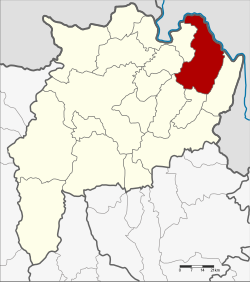
Chiang Khong District
Chiang Khong is a district located in the northeast part of Chiang Rai province in northern Thailand.[1] It shares borders with six other districts in Chiang Rai province. The Mekong River is the border between the north and northeast parts of the district. It separates the district from Laos.
Chiang Khong
เชียงของ | |
|---|---|
![Wat Phra Kaeo, Chiang Khong [th]](http://upload.wikimedia.org/wikipedia/commons/thumb/6/63/Wat_Phra_Kaew_Chiang_Khong_%E0%B8%A7%E0%B8%B1%E0%B8%94%E0%B8%9E%E0%B8%A3%E0%B8%B0%E0%B9%81%E0%B8%81%E0%B9%89%E0%B8%A7_%E0%B9%80%E0%B8%8A%E0%B8%B5%E0%B8%A2%E0%B8%87%E0%B8%82%E0%B8%AD%E0%B8%87_%28October_2021%29_-_img_02.jpg/250px-Wat_Phra_Kaew_Chiang_Khong_%E0%B8%A7%E0%B8%B1%E0%B8%94%E0%B8%9E%E0%B8%A3%E0%B8%B0%E0%B9%81%E0%B8%81%E0%B9%89%E0%B8%A7_%E0%B9%80%E0%B8%8A%E0%B8%B5%E0%B8%A2%E0%B8%87%E0%B8%82%E0%B8%AD%E0%B8%87_%28October_2021%29_-_img_02.jpg) | |
 District location in Chiang Rai province | |
| Coordinates: 20°15′36″N 100°24′24″E / 20.26000°N 100.40667°E | |
| Country | Thailand |
| Province | Chiang Rai |
| Seat | Wiang |
| Subdistricts | 7 |
| Mubans | 102 |
| Area | |
| • Total | 836.9 km2 (323.1 sq mi) |
| Population (2015) | |
| • Total | 64,197 |
| • Density | 76.1/km2 (197/sq mi) |
| Time zone | UTC+7 (ICT) |
| Postal code | 57140 |
| Geocode | 5703 |
Geography
changeIt has several mountains and valleys. The Phi Pan Nam mountains are the main mountains in the area. Doi Luang Pae Mueang, a large mountain 1,328 meters high, is located west of Chiang Khong town. Mekong River runs along the northern border of the district. Chiang Khong also has the Ing River. It flows into the Mekong River.
Area and population
changeIt covers a total area of 836.9 square kilometers. It is divided into 7 subdistricts containing 102 villages. As of 2015, it had a total population of 64,197 peoples.
References
change- ↑ "Trouble in Phrae – The Shan Rebellion of 1902". Siam Rat Blog. 25 July 2021. Retrieved 5 August 2023.