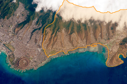
East Honolulu, Hawaii
census-designated place in Honolulu County, Hawaii, United States of America
East Honolulu is a census-designated place (CDP) in Honolulu County, Hawaii, United States. As of 2020, the CDP had a population of 50,922 people.[2]
East Honolulu | |
|---|---|
 | |
| Coordinates: 21°17′20″N 157°43′2″W / 21.28889°N 157.71722°W | |
| Country | |
| State | |
| Counties | |
| Area | |
| • Total | 34.45 sq mi (89.24 km2) |
| • Land | 23.01 sq mi (59.58 km2) |
| • Water | 11.45 sq mi (29.65 km2) |
| Population | |
| • Total | 50,922 |
| • Density | 2,213.42/sq mi (854.61/km2) |
| Time zone | UTC-10 (Hawaiian (HST)) |
| Area code | 808 |
| GNIS feature ID | 2583416[3] |
Geography
changeThe United States Census Bureau says that the CDP has an area of 34 mi2 (89 km2) and 33% of the area is water.[1]
The CDP is located on Oahu. The CDP starts directly east of the center of Honolulu, and ends at Makapu'u Point (which is the easternmost point on the island).
Demographics
changeThere are many races present in the CDP.[2]
- Asian 47.2% (24,021)
- White 23.4% (11,926)
- Mixed 20.2% (10,305)
- Hispanic 5.4% (2,767)
- Native Hawaiians or other Pacific Islanders 2.8% (1,441)
- Black 0.5% (278)
- Other races 0.4% (184)
As of 2022, the median income that households make in East Honolulu is about $151,224 USD.[4] 48.9% is males and 51.1% are female. The median age in the CDP is 50 years old.
References
change- ↑ 1.0 1.1 "2020 U.S. Gazetteer Files". United States Census Bureau. Retrieved December 18, 2021.
- ↑ 2.0 2.1 2.2 "Profile of General Population and Housing Characteristics: 2020 Demographic Profile Data (DP-1): East Honolulu CDP, Hawaii". United States Census Bureau. Retrieved February 28, 2024.
- ↑ "East Honolulu Census Designated Place". Geographic Names Information System. United States Geological Survey. Retrieved December 29, 2013.
- ↑ "S1901: Income in the Past 12 Months (in 2022 Inflation-Adjusted Dollars)". United States Census Bureau. Retrieved February 29, 2024.
